File:Mississippi floodways and spillways map by Charles H. Owens, 1928.jpg

Size of this preview: 304 × 599 pixels. Other resolutions: 122 × 240 pixels | 243 × 480 pixels | 389 × 768 pixels | 519 × 1,024 pixels | 1,039 × 2,048 pixels | 3,790 × 7,469 pixels.
Original file (3,790 × 7,469 pixels, file size: 2.89 MB, MIME type: image/jpeg)
Captions
Captions
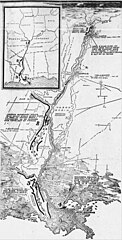
Map showing the proposed floodways and spillways of the Mississippi River by Charles Hamilton Owens, 1928.
Summary edit
| Description |
English: Map showing the proposed floodways and spillways of the Mississippi River by Charles Hamilton Owens, 1928.
From caption: "No. 1 shows the five-mile setback of the levee between Cairo and New Madrid. No. 2 is the Boeuf River basin floodway. No. 3 the Atchafalaya basin floodway and No. 4 spillway from Bonnet Carre above New Orleans into Lake Pontchartrain." |
| Date | January 15, 1928 |
| Source | Los Angeles Times via https://www.newspapers.com/article/the-los-angeles-times-mississippi-flood/138524696/ |
| Author | Charles Hamilton Owens |
Licensing edit
This work is in the public domain in the United States because it was published (or registered with the U.S. Copyright Office) before January 1, 1929.
Public domain works must be out of copyright in both the United States and in the source country of the work in order to be hosted on the Commons. If the work is not a U.S. work, the file must have an additional copyright tag indicating the copyright status in the source country.
Note: This tag should not be used for sound recordings. |
File history
Click on a date/time to view the file as it appeared at that time.
| Date/Time | Thumbnail | Dimensions | User | Comment | |
|---|---|---|---|---|---|
| current | 19:50, 11 January 2024 | | 3,790 × 7,469 (2.89 MB) | Pretzelles (talk | contribs) | Uploaded a work by Charles Hamilton Owens from ''Los Angeles Times'' via https://www.newspapers.com/article/the-los-angeles-times-mississippi-flood/138524696/ with UploadWizard |
You cannot overwrite this file.
File usage on Commons
There are no pages that use this file.