File:Mittelafrika2.svg

Size of this PNG preview of this SVG file: 635 × 600 pixels. Other resolutions: 254 × 240 pixels | 508 × 480 pixels | 813 × 768 pixels | 1,084 × 1,024 pixels | 2,169 × 2,048 pixels | 1,525 × 1,440 pixels.
Original file (SVG file, nominally 1,525 × 1,440 pixels, file size: 533 KB)
Captions
Captions
Add a one-line explanation of what this file represents
Summary
edit
| Description |
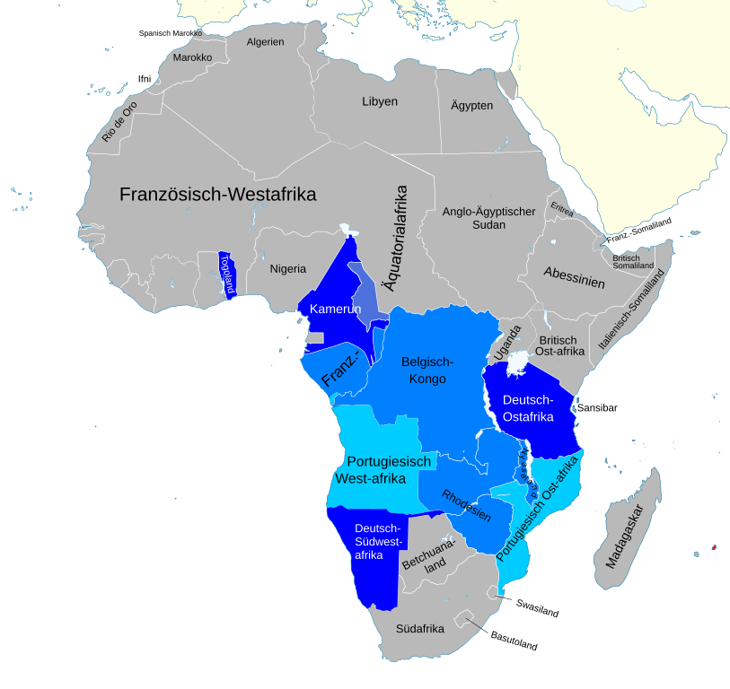
English: Map of the Mittelafrika idea, before 1914
Italiano: Mappa della Mittelafrika |
| Date | |
| Source | File:Kolonien-Afrikas.svg |
| Author | Hogweard |
Licensing
edit
I, the copyright holder of this work, hereby publish it under the following license:
This file is licensed under the Creative Commons Attribution-Share Alike 3.0 Unported license.
- You are free:
- to share – to copy, distribute and transmit the work
- to remix – to adapt the work
- Under the following conditions:
- attribution – You must give appropriate credit, provide a link to the license, and indicate if changes were made. You may do so in any reasonable manner, but not in any way that suggests the licensor endorses you or your use.
- share alike – If you remix, transform, or build upon the material, you must distribute your contributions under the same or compatible license as the original.
File history
Click on a date/time to view the file as it appeared at that time.
| Date/Time | Thumbnail | Dimensions | User | Comment | |
|---|---|---|---|---|---|
| current | 22:44, 11 September 2020 | | 1,525 × 1,440 (533 KB) | Hogweard (talk | contribs) | == {{int:filedesc}} == {{Information |Description={{en|1=Map of the Mittelafrika idea, before 1914}} {{it|1=Mappa della Mittelafrika}} |Source={{Kolonien Afrikas.svg}} |Author={{u|Hogweard}} |Date=2020-09-11 |Permission= |other_versions= }} == {{int:license-header}} == {{self|cc-by-sa-3.0}} Category:SVG maps showing history of Africa Category:Maps of colonial Africa Category:SVG maps showing history in German |
You cannot overwrite this file.
File usage on Commons
The following page uses this file: