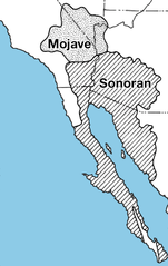
File:Mojave-sonoran deserts.png

Size of this preview: 379 × 600 pixels. Other resolutions: 151 × 240 pixels | 632 × 1,000 pixels.
Original file (632 × 1,000 pixels, file size: 309 KB, MIME type: image/png)
Captions
Captions
Add a one-line explanation of what this file represents
Summary edit

|
This locator map image could be re-created using vector graphics as an SVG file. This has several advantages; see Commons:Media for cleanup for more information. If an SVG form of this image is available, please upload it and afterwards replace this template with
{{vector version available|new image name}}.
It is recommended to name the SVG file “Mojave-sonoran deserts.svg”—then the template Vector version available (or Vva) does not need the new image name parameter. |
| Description | |
| Date | 28 March 2007 (original upload date) |
| Source | Archived source link |
| Author | USGS |
| Other versions |

Licensing edit
This image is in the public domain in the United States because it only contains materials that originally came from the United States Geological Survey, an agency of the United States Department of the Interior. For more information, see the official USGS copyright policy.
|
Original upload log edit
The original description page was here. All following user names refer to en.wikipedia.
- 2010-08-06 19:21 TimVickers 223×343× (58420 bytes) try again
- 2010-08-06 19:20 TimVickers 223×343× (69557 bytes) Colored in ocean so you can see where land and ocean are at a glance
- 2007-03-28 03:27 Rsduhamel 223×343× (69557 bytes) From: [http://wwwpaztcn.wr.usgs.gov/rsch_highlight/articles/200508.html http://wwwpaztcn.wr.usgs.gov/rsch_highlight/articles/200508.html]
File history
Click on a date/time to view the file as it appeared at that time.
| Date/Time | Thumbnail | Dimensions | User | Comment | |
|---|---|---|---|---|---|
| current | 23:31, 30 December 2015 | | 632 × 1,000 (309 KB) | WikiKiwi (talk | contribs) | oops, typo |
| 23:28, 30 December 2015 |  | 632 × 1,000 (309 KB) | WikiKiwi (talk | contribs) | Higher quality, better font | |
| 22:34, 7 November 2010 |  | 223 × 343 (57 KB) | File Upload Bot (Magnus Manske) (talk | contribs) | {{BotMoveToCommons|en.wikipedia|year={{subst:CURRENTYEAR}}|month={{subst:CURRENTMONTHNAME}}|day={{subst:CURRENTDAY}}}} {{Information |Description={{en|From: [http://wwwpaztcn.wr.usgs.gov/rsch_highlight/articles/200508.html http://wwwpaztcn.wr.usgs.gov/rs |
You cannot overwrite this file.
File usage on Commons
The following 4 pages use this file:
File usage on other wikis
The following other wikis use this file:
- Usage on ar.wikipedia.org
- Usage on az.wikipedia.org
- Usage on bg.wikipedia.org
- Usage on bn.wikipedia.org
- Usage on bs.wikipedia.org
- Usage on ckb.wikipedia.org
- Usage on de.wikipedia.org
- Usage on et.wikipedia.org
- Usage on fa.wikipedia.org
- Usage on fi.wikipedia.org
- Usage on hu.wikipedia.org
- Usage on it.wikipedia.org
- Usage on ka.wikipedia.org
- Usage on kk.wikipedia.org
- Usage on kn.wikipedia.org
- Usage on ko.wikipedia.org
- Usage on lfn.wikipedia.org
- Usage on lt.wikipedia.org
- Usage on mk.wikipedia.org
- Usage on ml.wikipedia.org
- Usage on mr.wikipedia.org
- Usage on pa.wikipedia.org
- Usage on pnb.wikipedia.org
- Usage on ro.wikipedia.org
- Usage on ru.wikipedia.org
- Usage on sq.wikipedia.org
- Usage on ta.wikipedia.org
- Usage on tr.wikipedia.org
- Usage on vi.wikipedia.org
- Usage on www.wikidata.org
- Usage on yo.wikipedia.org
- Usage on zh.wikipedia.org