File:Mono Lake Sunset (15949993563).jpg

Original file (2,048 × 1,365 pixels, file size: 993 KB, MIME type: image/jpeg)
Captions
Captions
Summary edit
.jpg&action=edit§ion=1)
| Description |
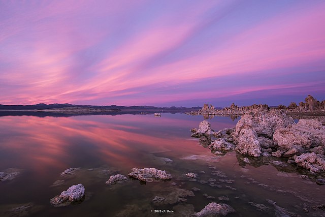
Mono Lake Sunset — Sometimes we're just suckers for a beautiful sunset. Today is one of those days. This sunset was taken over Mono Lake in California. The Mono Lake volcanic field, east of Yosemite National Park and north of the Mono Craters, consists of vents within Mono Lake and on its north shore. The most topographically prominent feature, Black Point, is an initially sublacustral (below lake level) basaltic cone that rises above the northwest shore and was formed about 13,300 years ago when Mono Lake was higher. Lava domes and flows form Negit and parts of Paoha islands within Mono Lake. The most recent eruptive activity in the Long Valley to Mono Lake region took place about 300 years ago, when lake-bottom sediments forming much of Paoha Island were uplifted by intrusion of a rhyolitic cryptodome. Spectacular tufa towers also line the shores of Mono Lake. Thanks to Sue B (firago on Flickr) for sharing this photo with the USGS Science in Action Flickr Group! Share your earth science photo for a chance to be featured in upcoming USGS products and social media: www.flickr.com/groups/usgsscience |
| Date | |
| Source | Mono Lake Sunset |
| Author | U.S. Geological Survey from Reston, VA, USA |
Licensing edit
.jpg&action=edit§ion=2)
- You are free:
- to share – to copy, distribute and transmit the work
- to remix – to adapt the work
- Under the following conditions:
- attribution – You must give appropriate credit, provide a link to the license, and indicate if changes were made. You may do so in any reasonable manner, but not in any way that suggests the licensor endorses you or your use.
| This image was originally posted to Flickr by U.S. Geological Survey at https://flickr.com/photos/27784370@N05/15949993563 (archive). It was reviewed on 19 January 2018 by FlickreviewR 2 and was confirmed to be licensed under the terms of the cc-by-2.0. |
This image is in the public domain in the United States because it only contains materials that originally came from the United States Geological Survey, an agency of the United States Department of the Interior. For more information, see the official USGS copyright policy.
|
File history
Click on a date/time to view the file as it appeared at that time.
| Date/Time | Thumbnail | Dimensions | User | Comment | |
|---|---|---|---|---|---|
| current | 20:36, 19 January 2018 | | 2,048 × 1,365 (993 KB) | Artix Kreiger 2 (talk | contribs) | Transferred from Flickr via Flickr2Commons |
You cannot overwrite this file.
File usage on Commons
There are no pages that use this file.
File usage on other wikis
The following other wikis use this file:
- Usage on pt.wikipedia.org
- Usage on www.wikidata.org
.jpg&oldid=698664168)