File:Montage of common terns (Sterna hirundo) near the southern cliffs of Santa Maria, Azores, Portugal (PPL1-Corrected) (approx. GPS location) julesvernex2.jpg

Size of this preview: 800 × 122 pixels. Other resolutions: 320 × 49 pixels | 640 × 97 pixels | 1,024 × 156 pixels | 1,280 × 194 pixels | 2,560 × 389 pixels | 23,124 × 3,513 pixels.
Original file (23,124 × 3,513 pixels, file size: 20.52 MB, MIME type: image/jpeg)
Captions
Captions
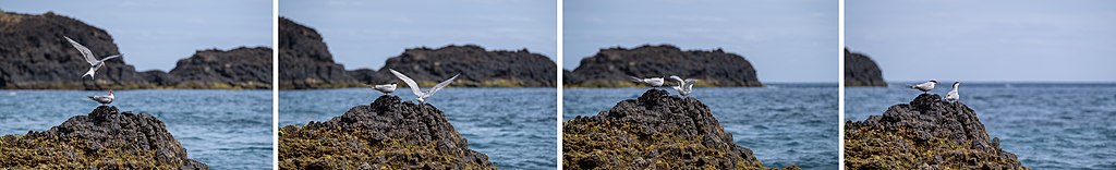
Montage of common terns (Sterna hirundo) near the southern cliffs of Santa Maria, Azores, Portugal (PPL1-Corrected) (approx. GPS location)
Summary edit
_near_the_southern_cliffs_of_Santa_Maria,_Azores,_Portugal_(PPL1-Corrected)_(approx._GPS_location)_julesvernex2.jpg&action=edit§ion=1)
| Warning | The original file is very high-resolution. It might not load properly or could cause your browser to freeze when opened at full size. |
|---|
| Description |
English: Montage of common terns (Sterna hirundo) near the southern cliffs of Santa Maria, Azores, Portugal (PPL1-Corrected) (approx. GPS location) |
| Date | |
| Source |
|
| Author | Jules Verne Times Two |
| Permission (Reusing this file) |
|
| Camera location | | View this and other nearby images on: OpenStreetMap |
|---|
_near_the_southern_cliffs_of_Santa_Maria,_Azores,_Portugal_(PPL1-Corrected)_(approx._GPS_location)_julesvernex2.jpg¶ms=036.931889_N_-025.079722_E_globe:Earth_type:camera__&language=en)
Licensing edit
_near_the_southern_cliffs_of_Santa_Maria,_Azores,_Portugal_(PPL1-Corrected)_(approx._GPS_location)_julesvernex2.jpg&action=edit§ion=2)
This file is licensed under the Creative Commons Attribution-Share Alike 4.0 International license.
Attribution: Jules Verne Times Two / www.julesvernex2.com
- You are free:
- to share – to copy, distribute and transmit the work
- to remix – to adapt the work
- Under the following conditions:
- attribution – You must give appropriate credit, provide a link to the license, and indicate if changes were made. You may do so in any reasonable manner, but not in any way that suggests the licensor endorses you or your use.
- share alike – If you remix, transform, or build upon the material, you must distribute your contributions under the same or compatible license as the original.
File history
Click on a date/time to view the file as it appeared at that time.
| Date/Time | Thumbnail | Dimensions | User | Comment | |
|---|---|---|---|---|---|
| current | 21:37, 4 December 2021 | 23,124 × 3,513 (20.52 MB) | Julesvernex2 (talk | contribs) | Uploaded with LrMediaWiki 0.8.0, LR 11.0.1 Win |
You cannot overwrite this file.
File usage on Commons
The following 4 pages use this file:
_near_the_southern_cliffs_of_Santa_Maria,_Azores,_Portugal_(PPL1-Corrected)_(approx._GPS_location)_julesvernex2.jpg&oldid=816497513)