File:Monte Bello Islands Map.jpg

Size of this preview: 542 × 599 pixels. Other resolutions: 217 × 240 pixels | 434 × 480 pixels | 695 × 768 pixels | 1,041 × 1,151 pixels.
Original file (1,041 × 1,151 pixels, file size: 266 KB, MIME type: image/jpeg)
Captions
Captions
Kannur West Beach House
Summary
edit
| Description |
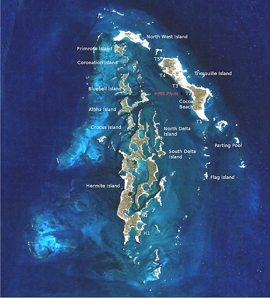
English: Map of the Monte Bello Islands, indicating sites for Operation Hurricane. Made from File:Montebello Islands-NASA.jpg and map in "A History of British Atomic Tests in Australia", p. 83 |
| Date | |
| Source | Own work |
| Author | Hawkeye7 |
Licensing
edit
I, the copyright holder of this work, hereby publish it under the following license:
This file is licensed under the Creative Commons Attribution-Share Alike 4.0 International license.
- You are free:
- to share – to copy, distribute and transmit the work
- to remix – to adapt the work
- Under the following conditions:
- attribution – You must give appropriate credit, provide a link to the license, and indicate if changes were made. You may do so in any reasonable manner, but not in any way that suggests the licensor endorses you or your use.
- share alike – If you remix, transform, or build upon the material, you must distribute your contributions under the same or compatible license as the original.
File history
Click on a date/time to view the file as it appeared at that time.
| Date/Time | Thumbnail | Dimensions | User | Comment | |
|---|---|---|---|---|---|
| current | 06:16, 21 February 2017 | | 1,041 × 1,151 (266 KB) | Hawkeye7 (talk | contribs) | User created page with UploadWizard |
You cannot overwrite this file.
File usage on Commons
There are no pages that use this file.
File usage on other wikis
The following other wikis use this file:
- Usage on en.wikipedia.org
- Usage on pt.wikipedia.org