File:Montieramey, Aube. Carte de Cassini.png

Original file (1,075 × 576 pixels, file size: 1.55 MB, MIME type: image/png)
Captions
Captions
Summary
edit
| Description |
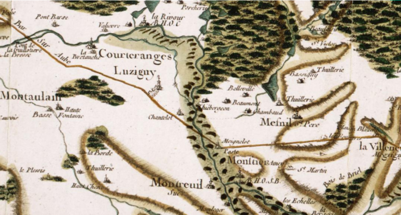
English: Portion of Cassini map showing the Montieramey abbey, Aube departement, Burgundy, France. The abbey is in the lower part of the picture, north-east of Montreuil (Montreuil-sur-Barse). It is spelled "Monƒtier-Amey", an uncommon spelling, followed by the initials "AB. H.O.S.B., standing for "Abbaye d'Hommes Ordre Saint Bernard" (Men Abbey Order of Saint Bernard).
The abbey is located on the river Barse, which flows north towards the Larrivour abbey (near the upper edge of the picture). The latter is "AB. H. O. C.", a men abbey of the cistercian order. The valley is woody all along, joining with the larger forêt d'Orient north-east. The road from Troyes (hardly 20 km north-east) to Bar-sur-Aube (32 km east) passes 1 km north of Montieramey. The village of La Villeneuve Egrigny on the right edge of the picture is now called La Villeneuve-au-Chêne.Français : Carte de Cassini, abbaye de Montiéramey, dans l'Aube, Bourgogne, France. L'abbaye est dans la partie basse de l'image, au nord-est de Montreuil (Montreuil-sur-Barse). Le nom est épelé "Monƒtier-Amey", orthographe peu commune, et est suivi des initiales "AB. H.O.S.B., "Abbaye d'Hommes Ordre Saint Bernard".
L'abbaye est sur la rivière Barse, qui coule vers le nord et vers l'abbaye de Larrivour (près du bord supérieur de l'image). Cette dernière est "AB. H. O. C.", une abbaye pour hommes de l'ordre de Citeaux. La vallée est boisée tout du long, ces bois rejoignant la forêt d'Orient au nord-est. La route de Troyes ( (à peine 20 km au nord-est) à Bar-sur-Aube (32 km à l'est) passe à 1 km au nord de Montieramey. Le village de La Villeneuve Egrigny sur le bord droit de l'image s'appelle de nos jours La Villeneuve-au-Chêne. |
| Date | |
| Source | geoportail.gouv.fr |
| Author | Cassini family (18th century) |
| Camera location | | View this and other nearby images on: OpenStreetMap |
|---|
The location coordinates are for the Montieramey abbey.
Licensing
edit
|
This work is in the public domain in its country of origin and other countries and areas where the copyright term is the author's life plus 70 years or fewer. This work is in the public domain in the United States because it was published (or registered with the U.S. Copyright Office) before January 1, 1929. | |
| This file has been identified as being free of known restrictions under copyright law, including all related and neighboring rights. | |
File history
Click on a date/time to view the file as it appeared at that time.
| Date/Time | Thumbnail | Dimensions | User | Comment | |
|---|---|---|---|---|---|
| current | 01:24, 31 May 2017 | | 1,075 × 576 (1.55 MB) | Pueblo89 (talk | contribs) | User created page with UploadWizard |
You cannot overwrite this file.
File usage on Commons
The following page uses this file:
File usage on other wikis
The following other wikis use this file:
- Usage on fr.wikipedia.org