File:Montreal at Night.JPG

Original file (4,256 × 2,832 pixels, file size: 2.13 MB, MIME type: image/jpeg)
Captions
Captions
Summary
edit
| Description |
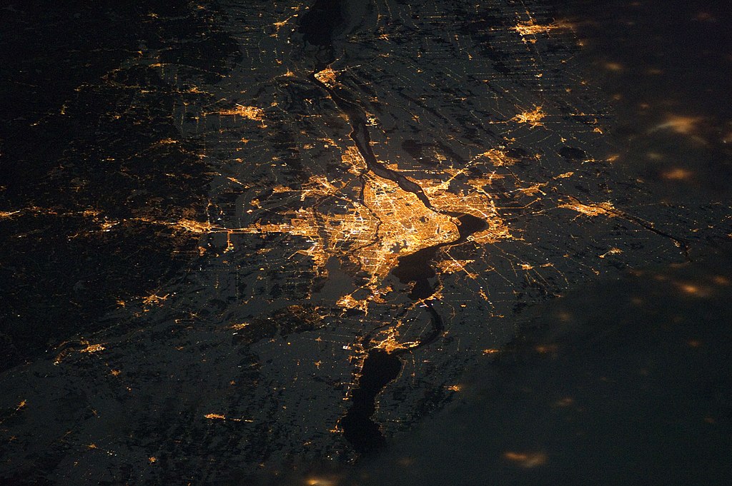
English: The Montreal metropolitan area (image centre) is Canada’s second-largest, having been surpassed by Toronto in 1976. While the city of Montreal is located on the Island of Montreal, at the confluence of the St. Lawrence (image centre) and Ottawa rivers (not visible), the city takes its name from Mont Royal, located at the city’s centre. This astronaut photograph of the city lights of Montreal illustrates the extent of urbanization. Major roadways and industrial areas are traced by bright white lighting, while the adjacent residential and commercial lands are characterized by more diffuse yellow-gold lighting. Rivers and other water bodies appear black, while the surrounding countryside is faintly illuminated by moonlight. Blurry areas at image top and bottom right are caused by cloud cover. |
| Date | |
| Source | NASA Earth Observatory |
| Author | ISS Expedition 26 crew |
| Camera location | | View this and other nearby images on: OpenStreetMap |
|---|
This image or video was catalogued by Johnson Space Center of the United States National Aeronautics and Space Administration (NASA) under Photo ID: ISS026-E-12474. This tag does not indicate the copyright status of the attached work. A normal copyright tag is still required. See Commons:Licensing. Other languages:
|
The International Space Station was located over the Pennsylvania-New York border (near Warren, Pa.) at the time this image was taken—a ground distance of approximately 600 kilometres south-west of Montreal. This distance from the camera target, coupled with the oblique (inclined) viewing angle from the ISS, results in the foreshortened appearance of urban areas in the image. Image acquired with a Nikon D3S digital camera using a 180 mm lens, and is provided by the ISS Crew Earth Observations experiment and Image Science & Analysis Laboratory, Johnson Space Center.
Licensing
edit
| This file is in the public domain in the United States because it was solely created by NASA. NASA copyright policy states that "NASA material is not protected by copyright unless noted". (See Template:PD-USGov, NASA copyright policy page or JPL Image Use Policy.) | ||
 |
Warnings:
|
| Annotations | This image is annotated: View the annotations at Commons |
File history
Click on a date/time to view the file as it appeared at that time.
| Date/Time | Thumbnail | Dimensions | User | Comment | |
|---|---|---|---|---|---|
| current | 12:17, 10 January 2011 | | 4,256 × 2,832 (2.13 MB) | Originalwana (talk | contribs) | {{Information |Description={{en|1=The Montreal metropolitan area (image centre) is Canada’s second-largest, having been surpassed by Toronto in 1976. While the city of Montreal is located on the Island of Montreal, at the confluence of the St. Lawre |
You cannot overwrite this file.
File usage on Commons
There are no pages that use this file.