File:Moor Lane, Stutton - geograph.org.uk - 574001.jpg
Size of this preview: 445 × 600 pixels. Other resolutions: 178 × 240 pixels | 475 × 640 pixels.
Original file (475 × 640 pixels, file size: 81 KB, MIME type: image/jpeg)
Captions
Captions
Add a one-line explanation of what this file represents
Summary edit
| Description |
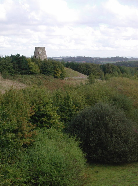
English: Moor Lane, Stutton Shown as a disused tip on the O/S 1:25000 scale map, this man-made valley north of Moor Lane was presumably once part of a string of local quarries where the much sought after milk white magnesium limestone was extracted from Roman times for buildings in the area including York Minster. The most famous of these quarries at Jackdaw Crag is a few hundred metres west of here, where crushed rock was more recently produced for the construction of the A1 motorway. The valley now forms part of the cutting for the busy A64 dual carriageway which is hidden by trees in the picture, with the old Stutton windmill now isolated and abandoned on the other side. |
| Date | |
| Source | From geograph.org.uk |
| Author | Paul Glazzard |
| Attribution (required by the license) | Paul Glazzard / Moor Lane, Stutton / |
| Camera location | | View this and other nearby images on: OpenStreetMap |
|---|
_heading:45.00&language=en)
| Object location | | View this and other nearby images on: OpenStreetMap |
|---|
_heading:45.00&language=en)
Licensing edit

|
This image was taken from the Geograph project collection. See this photograph's page on the Geograph website for the photographer's contact details. The copyright on this image is owned by Paul Glazzard and is licensed for reuse under the Creative Commons Attribution-ShareAlike 2.0 license.
|
This file is licensed under the Creative Commons Attribution-Share Alike 2.0 Generic license.
Attribution: Paul Glazzard
- You are free:
- to share – to copy, distribute and transmit the work
- to remix – to adapt the work
- Under the following conditions:
- attribution – You must give appropriate credit, provide a link to the license, and indicate if changes were made. You may do so in any reasonable manner, but not in any way that suggests the licensor endorses you or your use.
- share alike – If you remix, transform, or build upon the material, you must distribute your contributions under the same or compatible license as the original.
File history
Click on a date/time to view the file as it appeared at that time.
| Date/Time | Thumbnail | Dimensions | User | Comment | |
|---|---|---|---|---|---|
| current | 10:49, 6 February 2011 | | 475 × 640 (81 KB) | GeographBot (talk | contribs) | == {{int:filedesc}} == {{Information |description={{en|1=Moor Lane, Stutton Shown as a disused tip on the O/S 1:25000 scale map, this man-made valley north of Moor Lane was presumably once part of a string of local quarries where the much sought after mil |
You cannot overwrite this file.
File usage on Commons
There are no pages that use this file.