File:Morrell Antarctic Voyage 1822 ru.jpg
Morrell_Antarctic_Voyage_1822_ru.jpg (502 × 483 pixels, file size: 192 KB, MIME type: image/jpeg)
Captions
This image was uploaded in the JPEG format even though it consists of non-photographic data. This information could be stored more efficiently or accurately in the PNG or SVG format. If possible, please upload a PNG or SVG version of this image without compression artifacts, derived from a non-JPEG source (or with existing artifacts removed). After doing so, please tag the JPEG version with {{Superseded|NewImage.ext}} and remove this tag. This tag should not be applied to photographs or scans. If this image is a diagram or other image suitable for vectorisation, please tag this image with {{Convert to SVG}} instead of {{BadJPEG}}. If not suitable for vectorisation, use {{Convert to PNG}}. For more information, see {{BadJPEG}}. |
Summary
editDescriptionMorrell Antarctic Voyage 1822 ru.jpg |
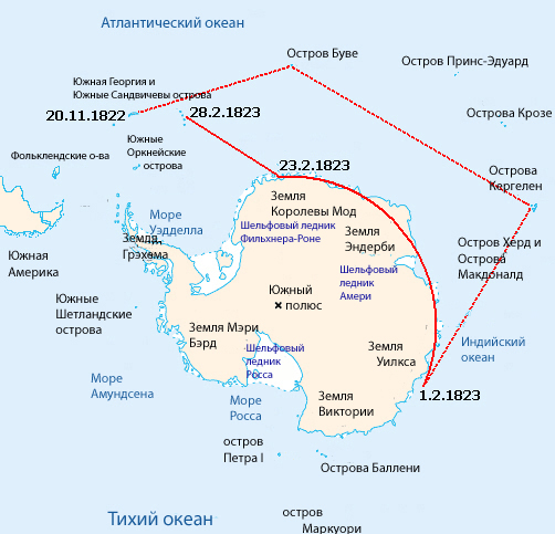
English: Map of the reported sea voyage of Benjamin Morrell near Antarctica in 1822-23. Positions and dates taken from Morrell's book:
Morrell, Benjamin (1832). A Narrative of Four Voyages...etc. New York: J & J Harper. Pages 58–66
Русский: Карта путешествия Бенджамина Морреля около берегов Антарктиды в 1822-1823 годах |
Date | |
Source | File:Morrell Antarctic Voyage 1822.png |
Author | User:Ruhrfisch adapted this from the map by Lupo, itself from the CIA factbook maps., russian translation of Yuriy Pedachenko |
Licensing
editPublic domainPublic domainfalsefalse |
This image is in the public domain because it contains materials that originally came from the United States Central Intelligence Agency's World Factbook.
Bahasa Indonesia ∙ čeština ∙ Deutsch ∙ eesti ∙ English ∙ español ∙ Esperanto ∙ français ∙ galego ∙ hrvatski ∙ italiano ∙ Nederlands ∙ norsk nynorsk ∙ polski ∙ português ∙ sicilianu ∙ slovenščina ∙ suomi ∙ Türkçe ∙ Zazaki ∙ беларуская (тарашкевіца) ∙ македонски ∙ русский ∙ српски / srpski ∙ українська ∙ ქართული ∙ বাংলা ∙ தமிழ் ∙ മലയാളം ∙ 한국어 ∙ 日本語 ∙ 中文 ∙ 中文(简体) ∙ 中文(繁體) ∙ العربية ∙ +/− |
File history
Click on a date/time to view the file as it appeared at that time.
Date/Time | Thumbnail | Dimensions | User | Comment | |
---|---|---|---|---|---|
current | 22:02, 3 December 2010 | 502 × 483 (192 KB) | Юрий Педаченко (talk | contribs) | {{Information |Description={{en|1=Map of the reported sea voyage of Benjamin Morrell near Antarctica in 1822-23. Positions and dates taken from Morrell's book: Morrell, Benjamin (1832). A Narrative of Four Voyages...etc. New York: J & J Harper. Pages 58� |
You cannot overwrite this file.
File usage on Commons
There are no pages that use this file.
File usage on other wikis
The following other wikis use this file:
- Usage on ru.wikipedia.org
Metadata
This file contains additional information such as Exif metadata which may have been added by the digital camera, scanner, or software program used to create or digitize it. If the file has been modified from its original state, some details such as the timestamp may not fully reflect those of the original file. The timestamp is only as accurate as the clock in the camera, and it may be completely wrong.
Orientation | Normal |
---|---|
Horizontal resolution | 72 dpi |
Vertical resolution | 72 dpi |
Software used | Adobe Photoshop CS Windows |
File change date and time | 01:50, 20 August 2010 |
Flash | Flash fired, compulsory flash suppression, No flash function, red-eye reduction mode |
Color space | Uncalibrated |