File:Moscow, west end of Sushchyovsky Val Street (31683818531).jpg

Size of this preview: 800 × 534 pixels. Other resolutions: 320 × 214 pixels | 640 × 427 pixels | 1,024 × 683 pixels | 1,280 × 854 pixels | 2,560 × 1,708 pixels | 3,264 × 2,178 pixels.
Original file (3,264 × 2,178 pixels, file size: 946 KB, MIME type: image/jpeg)
Captions
Captions
Add a one-line explanation of what this file represents
Summary edit
.jpg&action=edit§ion=1)
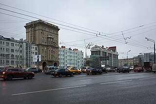
| Description | Москва, западная оконечность Сушевского Вала у Савеловской эстакады. Квартал разновысотных домов, фактически выходящий на Сущевский Вал, имеет нумерацию по Новослободской, 62. Боковые крылья 1930 и 1931 года, башня между ними 1953 года. Уплотнительная застройка тех времен. В 1941 именно в этом месте Сущёвский Вал был перегорожен противотанковыми заграждениями [1]. Никакой эстакады тогда не было, а был узенький Бутырский путепровод через Алексеевскую ветку, обслуживавший и направление север-юг, и запад-восток. |
| Date | |
| Source | Around Moscow |
| Author | Gennady Grachev from Moscow, Russia |
| Camera location | | View this and other nearby images on: OpenStreetMap |
|---|
.jpg¶ms=055.792630_N_0037.593413_E_globe:Earth_type:camera_source:Flickr_&language=en)
Licensing edit
.jpg&action=edit§ion=2)
This file is licensed under the Creative Commons Attribution 2.0 Generic license.
- You are free:
- to share – to copy, distribute and transmit the work
- to remix – to adapt the work
- Under the following conditions:
- attribution – You must give appropriate credit, provide a link to the license, and indicate if changes were made. You may do so in any reasonable manner, but not in any way that suggests the licensor endorses you or your use.
| This image was originally posted to Flickr by mvstang at https://flickr.com/photos/30084118@N00/31683818531. It was reviewed on 2 July 2018 by FlickreviewR 2 and was confirmed to be licensed under the terms of the cc-by-2.0. |
File history
Click on a date/time to view the file as it appeared at that time.
| Date/Time | Thumbnail | Dimensions | User | Comment | |
|---|---|---|---|---|---|
| current | 17:07, 2 July 2018 | | 3,264 × 2,178 (946 KB) | Balabinrm (talk | contribs) | Transferred from Flickr via #flickr2commons |
You cannot overwrite this file.
File usage on Commons
The following 2 pages use this file:
.jpg&redirect=no)
.jpg&oldid=490952604)