File:Mount Mazama Landsat5 2010-09-06.jpg

Size of this preview: 800 × 597 pixels. Other resolutions: 320 × 239 pixels | 640 × 478 pixels | 1,024 × 764 pixels | 1,280 × 955 pixels | 2,560 × 1,910 pixels | 3,180 × 2,373 pixels.
Original file (3,180 × 2,373 pixels, file size: 2.52 MB, MIME type: image/jpeg)
Captions
Captions
Add a one-line explanation of what this file represents
Summary edit
| Description |
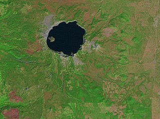
English: Satellite picture of Mount Mazama, a volcano in the Cascade Range, state of Oregon, United States.
Français : Image satellite du mont Mazama, un volcan de la chaîne des Cascades, dans l'État de l'Oregon, au nord-ouest des États-Unis. |
| Date | |
| Source | USGS Global Land Survey (GLS) Digital Object Identifier (DOI) number: /10.5066/F7M32TQB |
| Author | USGS - Landsat5 |
| Other versions | |
| Attribution (required by the license) | © Sémhur / Wikimedia Commons / |
| Object location | | View this and other nearby images on: OpenStreetMap |
|---|
Licensing edit
I, the copyright holder of this work, hereby publish it under the following licenses:
| Copyleft: This work of art is free; you can redistribute it and/or modify it according to terms of the Free Art License. You will find a specimen of this license on the Copyleft Attitude site as well as on other sites. |
This file is licensed under the Creative Commons Attribution-Share Alike 4.0 International, 3.0 Unported, 2.5 Generic, 2.0 Generic and 1.0 Generic license.
- You are free:
- to share – to copy, distribute and transmit the work
- to remix – to adapt the work
- Under the following conditions:
- attribution – You must give appropriate credit, provide a link to the license, and indicate if changes were made. You may do so in any reasonable manner, but not in any way that suggests the licensor endorses you or your use.
- share alike – If you remix, transform, or build upon the material, you must distribute your contributions under the same or compatible license as the original.
You may select the license of your choice.
File history
Click on a date/time to view the file as it appeared at that time.
| Date/Time | Thumbnail | Dimensions | User | Comment | |
|---|---|---|---|---|---|
| current | 17:59, 24 November 2019 | | 3,180 × 2,373 (2.52 MB) | Sémhur (talk | contribs) | Larger picture |
| 11:23, 24 November 2019 |  | 2,802 × 1,990 (2.16 MB) | Sémhur (talk | contribs) | == {{int:filedesc}} == {{Information |Description= {{en|1= Satellite picture of {{w|Mount Mazama||en}}, a volcano in the Cascade Range, state of Oregon, United States.}} {{fr|Image satellite du {{w|mont Mazama||fr}}, un volcan de la chaîne des Cascades, dans l'État de l'Oregon, au nord-ouest des États-Unis.}} |Source=[https://doi.org/10.5066/F7M32TQB USGS] Global Land Survey (GLS) Digital Object Identifier (DOI) number: /10.5066/F7M32TQB {|Date=2010-09-06 |Author=USGS - Landsat5 |other_versio... |
You cannot overwrite this file.
File usage on Commons
The following page uses this file:
File usage on other wikis
The following other wikis use this file:
- Usage on fr.wikipedia.org
- Usage on it.wikipedia.org