File:Mount Wellington And Stonefields Quarry II.jpg

Size of this preview: 800 × 600 pixels. Other resolutions: 320 × 240 pixels | 640 × 480 pixels | 1,024 × 768 pixels | 1,280 × 960 pixels | 1,600 × 1,200 pixels.
Original file (1,600 × 1,200 pixels, file size: 1.17 MB, MIME type: image/jpeg)
Captions
Captions
Add a one-line explanation of what this file represents
Summary
edit
| Description |
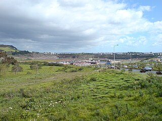
English: The 'Stonefields' suburb in the rear right, newly developed and mostly without houses yet - part of the Mount Wellington (rear left) area of Auckland City, New Zealand. Looking southwards from near the netball stadium. |
| Date | |
| Source | Self-photographed |
| Author | Ingolfson |
| Camera location | | View this and other nearby images on: OpenStreetMap |
|---|
Licensing
edit
| I, the copyright holder of this work, release this work into the public domain. This applies worldwide. In some countries this may not be legally possible; if so: I grant anyone the right to use this work for any purpose, without any conditions, unless such conditions are required by law. |
File history
Click on a date/time to view the file as it appeared at that time.
| Date/Time | Thumbnail | Dimensions | User | Comment | |
|---|---|---|---|---|---|
| current | 21:24, 4 January 2009 | | 1,600 × 1,200 (1.17 MB) | Ingolfson (talk | contribs) | == Summary == {{Information |Description=The 'Stonefields' suburb in the rear right, newly developed and mostly without houses yet - part of the Mount Wellington (rear left) area of Auckland City, New Zealand. Loo |
You cannot overwrite this file.
File usage on Commons
There are no pages that use this file.