File:Moving Hall Bridge - Hall Bridge, Spanning Saxtons River at Paradise Hill Road, Rockingham, Windham County, VT HAER VT-40 (sheet 6 of 6).tif

Size of this JPG preview of this TIF file: 800 × 533 pixels. Other resolutions: 320 × 213 pixels | 640 × 427 pixels | 1,024 × 683 pixels | 1,280 × 853 pixels | 2,560 × 1,707 pixels | 14,400 × 9,600 pixels.
Original file (14,400 × 9,600 pixels, file size: 519 KB, MIME type: image/tiff)
Captions
Captions
Add a one-line explanation of what this file represents
Summary edit
| Warning | The original file is very high-resolution. It might not load properly or could cause your browser to freeze when opened at full size. |
|---|
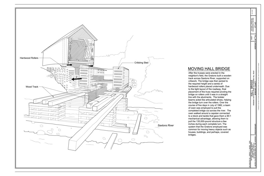
| Moving Hall Bridge - Hall Bridge, Spanning Saxtons River at Paradise Hill Road, Rockingham, Windham County, VT | ||||
|---|---|---|---|---|
| Photographer |
Mauro, Jeremy T., creator |
|||
| Title |
Moving Hall Bridge - Hall Bridge, Spanning Saxtons River at Paradise Hill Road, Rockingham, Windham County, VT |
|||
| Description |
Graton Associates; Town, Ithiel; Granger, Sanford; Graton, Milton S; Andrews, Timothy; Barns and Bridges of New England; Osgood, Holland W; Farnsworth Construction Company; Graton, Austin; Graton, Arnold M; Graton, Arnold, Jr; Arnold M. Graton Associates Inc.; H.E. Bergeron Engineers; Marston, Christopher H, project manager; Christianson, Justine, transmitter; Kidd, Anne E, field team project manager; Mauro, Jeremy T, field team; Rowley, Bradley M, field team; Bartha, Csaba, field team; Wright, David, consultant; Federal Highway Administration's National Historic Covered Bridge Preservation Program, sponsor |
|||
| Depicted place | Vermont; Windham County; Rockingham | |||
| Date | 2009 | |||
| Dimensions | 24 x 36 in. (D size) | |||
| Current location |
Library of Congress Prints and Photographs Division Washington, D.C. 20540 USA http://hdl.loc.gov/loc.pnp/pp.print |
|||
| Accession number |
HAER VT-40 (sheet 6 of 6) |
|||
| Credit line |
|
|||
| Notes |
|
|||
| Source | https://www.loc.gov/pictures/item/vt0166.sheet.00006a | |||
| Permission (Reusing this file) |
|
|||
| Other versions |
.png) .png) |
|||

| Object location | | View this and other nearby images on: OpenStreetMap |
|---|
File history
Click on a date/time to view the file as it appeared at that time.
| Date/Time | Thumbnail | Dimensions | User | Comment | |
|---|---|---|---|---|---|
| current | 17:17, 4 August 2014 |  | 14,400 × 9,600 (519 KB) | Fæ (talk | contribs) | GWToolset: Creating mediafile for Fæ. HABS 2014-08-04 (3601:3800) Penultimate Tranche! |
You cannot overwrite this file.
File usage on Commons
The following page uses this file: