File:MtChurchill-CalderaRim.jpg

Size of this preview: 800 × 555 pixels. Other resolutions: 320 × 222 pixels | 640 × 444 pixels | 1,024 × 711 pixels.
Original file (1,024 × 711 pixels, file size: 231 KB, MIME type: image/jpeg)
Captions
Captions
Add a one-line explanation of what this file represents
Summary edit
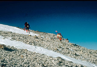
| Description | U.S. Geological Survey climbing party reaching the east rim of the summit caldera on 4,766-m (15,636 ft)-high Mount Churchill, site of two of the most voluminous explosive eruptions in North America in the past 2,000 years. Blocky debris in the photo consists of pumice and lithic fragments ejected 1,250 years ago. This deposit forms the eastern lobe of the White River Ash. Wrangell-St. Elias National Park and Preserve, Alaska, USA | |||
| Location | Wrangell-St. Elias National Park and Preserve, Alaska, USA | |||
| Date | ||||
| Source | http://pubs.usgs.gov/dds/dds-39/ | |||
| Author | G. Dubois, U.S. Geological Survey | |||
| Permission (Reusing this file) |
|
File history
Click on a date/time to view the file as it appeared at that time.
| Date/Time | Thumbnail | Dimensions | User | Comment | |
|---|---|---|---|---|---|
| current | 04:19, 22 April 2007 | | 1,024 × 711 (231 KB) | Seattle Skier (talk | contribs) | {{Information |Description= U.S. Geological Survey climbing party reaching the east rim of the summit caldera on 4,766-m (15,636 ft)-high Mount Churchill, site of two of the most voluminous explosive |
You cannot overwrite this file.
File usage on Commons
There are no pages that use this file.
File usage on other wikis
The following other wikis use this file:
- Usage on ceb.wikipedia.org
- Usage on en.wikipedia.org
- Usage on es.wikipedia.org
- Usage on fr.wikipedia.org
- Usage on nl.wikipedia.org
- Usage on zh.wikipedia.org