File:Mud Island Monorail satellite image Memphis TN.jpg
Mud_Island_Monorail_satellite_image_Memphis_TN.jpg (429 × 240 pixels, file size: 73 KB, MIME type: image/jpeg)
Captions
Captions
Summary edit
| DescriptionMud Island Monorail satellite image Memphis TN.jpg |
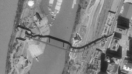
English: Satellite image of the Memphis Suspension Railway/Mud Island Monorail.
Original imagery by USGS, retrieved with ACME Mapper 2.0 |
| Date | |
| Source | http://mapper.acme.com/?ll=35.14685,-89.95361&z=17&t=O |
| Author | Thomas R Machnitzki |
Licensing edit
| Public domainPublic domainfalsefalse |
This image is in the public domain in the United States because it only contains materials that originally came from the United States Geological Survey, an agency of the United States Department of the Interior. For more information, see the official USGS copyright policy.
Bahasa Indonesia ∙ català ∙ čeština ∙ Deutsch ∙ eesti ∙ English ∙ español ∙ français ∙ galego ∙ italiano ∙ Nederlands ∙ português ∙ polski ∙ sicilianu ∙ suomi ∙ Tiếng Việt ∙ Türkçe ∙ български ∙ македонски ∙ русский ∙ മലയാളം ∙ 한국어 ∙ 日本語 ∙ 中文 ∙ 中文(简体) ∙ 中文(繁體) ∙ العربية ∙ فارسی ∙ +/− |
File history
Click on a date/time to view the file as it appeared at that time.
| Date/Time | Thumbnail | Dimensions | User | Comment | |
|---|---|---|---|---|---|
| current | 22:50, 15 September 2010 |  | 429 × 240 (73 KB) | DoxTxob (talk | contribs) | {{Information |Description={{en|1=Satellite image of the Memphis Suspension Railway/Mud Island Monorail. Original imagery by USGS, retrieved with ACME Mapper 2.0}} |Source=http://mapper.acme.com/?ll=35.14685,-89.95361&z=17&t=O |Author=Thomas R Machnitzki |
You cannot overwrite this file.
File usage on Commons
There are no pages that use this file.
Metadata
This file contains additional information such as Exif metadata which may have been added by the digital camera, scanner, or software program used to create or digitize it. If the file has been modified from its original state, some details such as the timestamp may not fully reflect those of the original file. The timestamp is only as accurate as the clock in the camera, and it may be completely wrong.
| _error | 0 |
|---|

