File:MuniKathmandu.png

Size of this preview: 800 × 443 pixels. Other resolutions: 320 × 177 pixels | 640 × 354 pixels | 1,024 × 567 pixels | 1,618 × 896 pixels.
Original file (1,618 × 896 pixels, file size: 1.87 MB, MIME type: image/png)
Captions
Captions
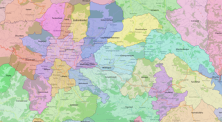
Municipalities of Kathmandu
Summary
edit
| Description |
English: Municipalities of Kathmandu District (and adjacent area) as mapped in OSM; image created with QGIS |
| Date | |
| Source | Own work |
| Author | Heinz OSM |
Licensing
edit
| This work contains information from OpenStreetMap, which is made available under the Open Database License (ODbL).
The ODbL does not require any particular license for maps produced from ODbL data. Prior to 1 August 2020, map tiles produced by the OpenStreetMap Foundation were licensed under the CC-BY-SA-2.0 license. Maps produced by other people may be subject to other licences. |
File history
Click on a date/time to view the file as it appeared at that time.
| Date/Time | Thumbnail | Dimensions | User | Comment | |
|---|---|---|---|---|---|
| current | 18:16, 4 March 2021 | | 1,618 × 896 (1.87 MB) | Heinz OSM (talk | contribs) | Uploaded own work with UploadWizard |
You cannot overwrite this file.
File usage on Commons
The following page uses this file:
File usage on other wikis
The following other wikis use this file:
- Usage on en.wikipedia.org