File:Myotis blythii range Map.png

Size of this preview: 800 × 407 pixels. Other resolutions: 320 × 163 pixels | 640 × 325 pixels | 1,024 × 521 pixels | 1,280 × 651 pixels | 2,753 × 1,400 pixels.
Original file (2,753 × 1,400 pixels, file size: 144 KB, MIME type: image/png)
Captions
Captions
Add a one-line explanation of what this file represents
Summary edit
| Description |
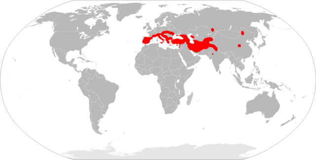
English: Myotis blythii range map.
Español: Mapa de distribución de Myotis blythii. |
| Date | |
| Source | Wikimedia Commons |
| Author | Carlos Bartolomé La Huerta |
| Other versions |
|
Licensing edit
This file is licensed under the Creative Commons Attribution-Share Alike 3.0 Unported license.
- You are free:
- to share – to copy, distribute and transmit the work
- to remix – to adapt the work
- Under the following conditions:
- attribution – You must give appropriate credit, provide a link to the license, and indicate if changes were made. You may do so in any reasonable manner, but not in any way that suggests the licensor endorses you or your use.
- share alike – If you remix, transform, or build upon the material, you must distribute your contributions under the same or compatible license as the original.
File history
Click on a date/time to view the file as it appeared at that time.
| Date/Time | Thumbnail | Dimensions | User | Comment | |
|---|---|---|---|---|---|
| current | 20:06, 21 March 2018 | | 2,753 × 1,400 (144 KB) | Maphobbyist (talk | contribs) | South Sudan border |
| 01:13, 23 February 2010 |  | 2,753 × 1,400 (146 KB) | Osado (talk | contribs) | ajuste al area indicada por IUNC | |
| 08:22, 8 February 2010 |  | 2,126 × 984 (67 KB) | Carlosblh (talk | contribs) | {{Information |Description={{en|1=Myotis blythii range map.}} {{es|1=Mapa de distribución de ''Myotis blythii''.}} |Source=Wikimedia Commons |Author=Carlos Bartolomé La Huerta |Date=2010/20/08 |Permission= |other_versions=[[File:Blank |
You cannot overwrite this file.
File usage on Commons
The following page uses this file:
File usage on other wikis
The following other wikis use this file:
- Usage on arz.wikipedia.org
- Usage on avk.wikipedia.org
- Usage on bg.wikipedia.org
- Usage on ca.wikipedia.org
- Usage on ceb.wikipedia.org
- Usage on cs.wikipedia.org
- Usage on de.wikipedia.org
- Usage on en.wikipedia.org
- Usage on es.wikipedia.org
- Usage on eu.wikipedia.org
- Usage on fa.wikipedia.org
- Usage on fr.wikipedia.org
- Liste des mammifères en France métropolitaine
- Liste des mammifères en Espagne
- Liste des mammifères en Suisse
- Liste des mammifères au Portugal continental
- Liste des mammifères en Italie
- Liste des mammifères en Allemagne
- Liste des mammifères en Roumanie
- Liste des mammifères en Grèce
- Liste des mammifères en Autriche
- Liste des mammifères au Vatican
- Liste des mammifères en Pologne
- Liste des mammifères en Andorre
- Liste des mammifères en Tchéquie
- Liste des mammifères en Croatie
- Liste des mammifères en Hongrie
- Liste des mammifères en Ukraine
- Liste des mammifères à Monaco
- Liste des mammifères à Chypre
- Liste des mammifères à Saint-Marin
- Liste des mammifères en Serbie
- Liste des mammifères en Bulgarie
- Liste des mammifères en Moldavie
- Liste des mammifères en Slovaquie
- Liste des mammifères en Albanie
- Liste des mammifères en Slovénie
- Liste des mammifères en Bosnie-Herzégovine
- Liste des mammifères en Macédoine du Nord
- Liste des mammifères au Monténégro
View more global usage of this file.