File:Nógrád megye önkormányzati választókerületi térképe 2010-2014.svg

Size of this PNG preview of this SVG file: 273 × 197 pixels. Other resolutions: 320 × 231 pixels | 640 × 462 pixels | 1,024 × 739 pixels | 1,280 × 924 pixels | 2,560 × 1,847 pixels.
Original file (SVG file, nominally 273 × 197 pixels, file size: 52 KB)
Captions
Captions
Add a one-line explanation of what this file represents
Summary edit
| Description |
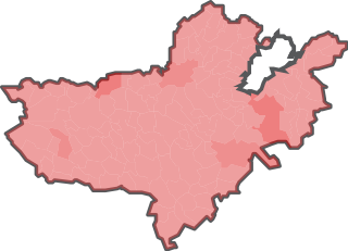
Magyar: Nógrád megye önkormányzati választókerületi térképe 2010-ben és 2014-ben. A megyei önkormányzati választásokon 2010-ben és 2014-ben használt választókerületi beosztás. A halvány piros szín jelöli a megyei közgyűlés válaszókerületét: ez a megye összes települése, leszámítva Salgótarjánt, mint megyei jogú várost. A leghalványabb piros a községeket, a közepes árnyalat a legfeljebb 10 ezer fős városokat (Rétság, Szécsény, Pásztó), a legerősebb piros szín pedig az 10 ezer fő fölötti városokat jelzi (Bátonyterenye és Balassagyarmat). |
| Date | |
| Source | saját munka, a KSH 2016-os közigazgatási térképe alapján, http://www.ksh.hu/docs/teruletiatlasz/telepulesek.pdf |
| Author | Egyed vita 2017. január 22., 20:50 (CET) |
| Permission (Reusing this file) |
kettős licenc |
Licensing edit
I, the copyright holder of this work, hereby publish it under the following licenses:

|
Permission is granted to copy, distribute and/or modify this document under the terms of the GNU Free Documentation License, Version 1.2 or any later version published by the Free Software Foundation; with no Invariant Sections, no Front-Cover Texts, and no Back-Cover Texts. A copy of the license is included in the section entitled GNU Free Documentation License. |
This file is licensed under the Creative Commons Attribution-Share Alike 3.0 Unported license.
- You are free:
- to share – to copy, distribute and transmit the work
- to remix – to adapt the work
- Under the following conditions:
- attribution – You must give appropriate credit, provide a link to the license, and indicate if changes were made. You may do so in any reasonable manner, but not in any way that suggests the licensor endorses you or your use.
- share alike – If you remix, transform, or build upon the material, you must distribute your contributions under the same or compatible license as the original.
You may select the license of your choice.
Original upload log edit
The original description page was here. All following user names refer to hu.wikipedia.
| Date/Time | Dimensions | User | Comment |
|---|---|---|---|
| 2017-01-22 19:50 | 273×197× (52845 bytes) | Egyed | {{Információ | leírás = Nógrád megye önkormányzati választókerületi térképe 2010-ben és 2014-ben. A megyei önkormányzati választásokon 2010-ben és 2014-ben használt választókerületi beosztás. A halvány piros szín jelö… |
File history
Click on a date/time to view the file as it appeared at that time.
| Date/Time | Thumbnail | Dimensions | User | Comment | |
|---|---|---|---|---|---|
| current | 10:53, 24 January 2017 | | 273 × 197 (52 KB) | Rakás (talk | contribs) | Transferred from hu.wikipedia |
You cannot overwrite this file.
File usage on Commons
There are no pages that use this file.
File usage on other wikis
The following other wikis use this file:
- Usage on hu.wikipedia.org