File:NASA-MOLA-Map-MangalaFossa.jpg
Size of this preview: 510 × 599 pixels. Other resolutions: 204 × 240 pixels | 536 × 630 pixels.
Original file (536 × 630 pixels, file size: 76 KB, MIME type: image/jpeg)
Captions
Captions
Add a one-line explanation of what this file represents
Summary
edit
| Description |
English: http://eprints.lancs.ac.uk/31116/1/2005JE002644.pdf
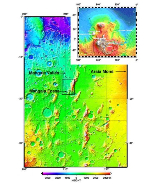
IMAGE DESCRIPTION: Figure 1. Color-coded MOLA topography of Mangala Valles floodplain, Mangala Fossa source graben, and highland topography containing proposed aquifer system feeding the valley. Box shows location of Figure 2. Inset is of Tharsis volcanic area. |
| Date | |
| Source | JPG-image converted (via GIMP v2.8) from PDF-image at http://eprints.lancs.ac.uk/31116/1/2005JE002644.pdf |
| Author | NASA / JPL / Goddard Space Flight Center |
Licensing
edit
| This file is in the public domain in the United States because it was solely created by NASA. NASA copyright policy states that "NASA material is not protected by copyright unless noted". (See Template:PD-USGov, NASA copyright policy page or JPL Image Use Policy.) | ||
 |
Warnings:
|
File history
Click on a date/time to view the file as it appeared at that time.
| Date/Time | Thumbnail | Dimensions | User | Comment | |
|---|---|---|---|---|---|
| current | 14:29, 4 December 2015 | | 536 × 630 (76 KB) | Drbogdan (talk | contribs) | User created page with UploadWizard |
You cannot overwrite this file.
File usage on Commons
There are no pages that use this file.