File:NASA Selects L3Harris to Develop NOAA GeoXO Imager (NESDIS 2023-03-13).jpg

Size of this preview: 800 × 450 pixels. Other resolutions: 320 × 180 pixels | 640 × 360 pixels | 1,024 × 576 pixels | 1,280 × 720 pixels | 2,560 × 1,440 pixels | 3,840 × 2,160 pixels.
Original file (3,840 × 2,160 pixels, file size: 3.8 MB, MIME type: image/jpeg)
Captions
Captions
Add a one-line explanation of what this file represents
Summary
edit.jpg&action=edit§ion=1)
| Description |
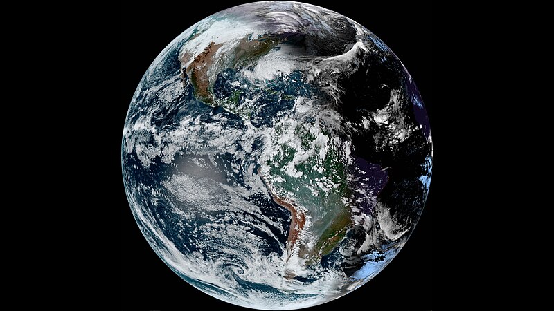
English: NASA, on behalf of the National Oceanic and Atmospheric Administration (NOAA), has selected L3Harris Technologies Inc. of Fort Wayne, Indiana, to develop the imager for NOAA’s Geostationary Extended Observations (GeoXO) satellite program. This cost-plus-award-fee contract is valued at approximately $765.5 million. It includes the development of two flight instruments as well as options for additional units. The anticipated period of performance for this contract includes support for 10 years of on-orbit operations and five years of on-orbit storage, for a total of 15 years for each flight model. The work will be completed at L3Harris facilities, NASA’s Goddard Space Flight Center in Greenbelt, Maryland, and the agency’s Kennedy Space Center in Florida. The GeoXO Imager (GXI) is the primary instrument for the GeoXO mission. GXI is a multi-channel, passive imaging radiometer used to measure environmental data. The instrument will provide real-time, high-resolution visible and infrared imagery for monitoring the Western Hemisphere’s weather, ocean, and environment. GXI will be used for a wide range of applications related to severe storms, hurricanes, aviation, natural hazards, the atmosphere and ocean. GXI will monitor cloud formation, atmospheric motion, convection, land surface temperature, fire, smoke, dust, volcanic ash plumes, aerosols, air quality, vegetative health, and more. The contract scope includes the tasks and deliverables necessary to design, analyze, develop, fabricate, integrate, test, verify, evaluate, support launch, supply and maintain the instrument ground support equipment, and support mission operations at the NOAA Satellite Operations Facility. NOAA operates a constellation of geostationary environmental satellites to protect life and property across the Western Hemisphere. The GeoXO program is the follow-on to the Geostationary Operational Environmental Satellites – R (GOES-R) Series program. The GeoXO satellite system will advance Earth observations from geostationary orbit. The mission will supply vital information to address major environmental challenges of the future in support of weather, ocean, and climate operations in the United States. GeoXO’s advanced capabilities will help address our changing planet and the evolving needs of NOAA’s data users. NOAA and NASA are working to ensure these critical observations are in place by the early 2030s when the GOES-R Series nears the end of its operational lifetime. Together, NOAA and NASA will oversee the development, launch, testing, and operation of all the satellites in the GeoXO program. NOAA funds and manages the program, operations, and data products. On behalf of NOAA, NASA and commercial partners develop and build the instruments, spacecraft, and ground system, and launch the satellites. |
| Date | 13 March 2023 (upload date) |
| Source | NASA Selects L3Harris to Develop NOAA GeoXO Imager |
| Author | NOAA |
Licensing
edit.jpg&action=edit§ion=2)
This image is in the public domain because it contains materials that originally came from the U.S. National Oceanic and Atmospheric Administration, taken or made as part of an employee's official duties.
|
File history
Click on a date/time to view the file as it appeared at that time.
| Date/Time | Thumbnail | Dimensions | User | Comment | |
|---|---|---|---|---|---|
| current | 08:30, 5 June 2024 | | 3,840 × 2,160 (3.8 MB) | OptimusPrimeBot (talk | contribs) | #Spacemedia - Upload of https://nesdis-prod.s3.amazonaws.com/2023-03/20223132030-UHDglobe_01-%281%29.jpg via Commons:Spacemedia |
You cannot overwrite this file.
File usage on Commons
There are no pages that use this file.
.jpg&oldid=881446531)