File:NCN sign on the Granite Way - geograph.org.uk - 319452.jpg
Size of this preview: 445 × 600 pixels. Other resolutions: 178 × 240 pixels | 475 × 640 pixels.
Original file (475 × 640 pixels, file size: 142 KB, MIME type: image/jpeg)
Captions
Captions
Add a one-line explanation of what this file represents
Summary edit
| Description |
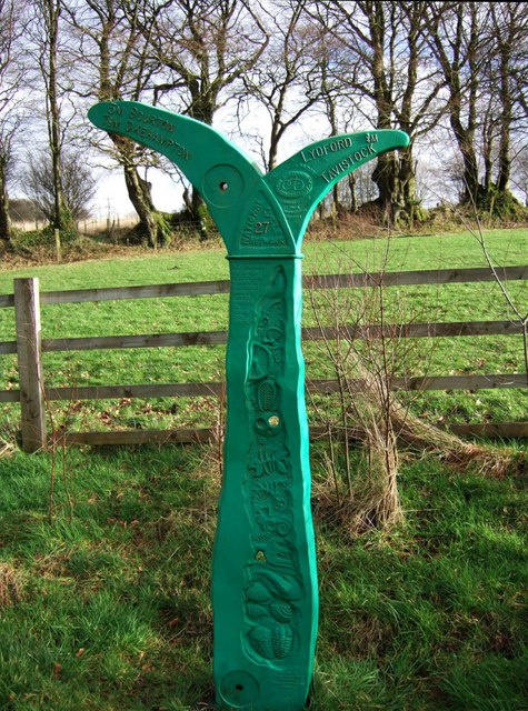
English: NCN sign on the Granite Way A National Cycle Network sign on route 27, placed beside a concrete shelter at the side of the former Okehampton-Tavistock railway, on Battishill Down. Reluctant to say how far it is to Tavistock. |
| Date | |
| Source | From geograph.org.uk |
| Author | Derek Harper |
| Attribution (required by the license) | Derek Harper / NCN sign on the Granite Way / |
| Camera location | | View this and other nearby images on: OpenStreetMap |
|---|
_heading:112.00&language=en)
| Object location | | View this and other nearby images on: OpenStreetMap |
|---|
_heading:112.00&language=en)
Licensing edit

|
This image was taken from the Geograph project collection. See this photograph's page on the Geograph website for the photographer's contact details. The copyright on this image is owned by Derek Harper and is licensed for reuse under the Creative Commons Attribution-ShareAlike 2.0 license.
|
This file is licensed under the Creative Commons Attribution-Share Alike 2.0 Generic license.
Attribution: Derek Harper
- You are free:
- to share – to copy, distribute and transmit the work
- to remix – to adapt the work
- Under the following conditions:
- attribution – You must give appropriate credit, provide a link to the license, and indicate if changes were made. You may do so in any reasonable manner, but not in any way that suggests the licensor endorses you or your use.
- share alike – If you remix, transform, or build upon the material, you must distribute your contributions under the same or compatible license as the original.
File history
Click on a date/time to view the file as it appeared at that time.
| Date/Time | Thumbnail | Dimensions | User | Comment | |
|---|---|---|---|---|---|
| current | 15:21, 30 December 2010 | | 475 × 640 (142 KB) | GeographBot (talk | contribs) | == {{int:filedesc}} == {{Information |description={{en|1=NCN sign on the Granite Way A National Cycle Network sign on route 27, placed beside a concrete shelter at the side of the former Okehampton-Tavistock railway, on Battishill Down. Reluctant to say h |
You cannot overwrite this file.
File usage on Commons
The following 2 pages use this file:
File usage on other wikis
The following other wikis use this file:
- Usage on en.wikipedia.org
- Usage on www.wikidata.org