File:NJT railmap infobox.svg

Size of this PNG preview of this SVG file: 329 × 600 pixels. Other resolutions: 131 × 240 pixels | 263 × 480 pixels | 421 × 768 pixels | 561 × 1,024 pixels | 1,123 × 2,048 pixels | 2,720 × 4,960 pixels.
Original file (SVG file, nominally 2,720 × 4,960 pixels, file size: 768 KB)
Captions
Captions
Add a one-line explanation of what this file represents
| Description |
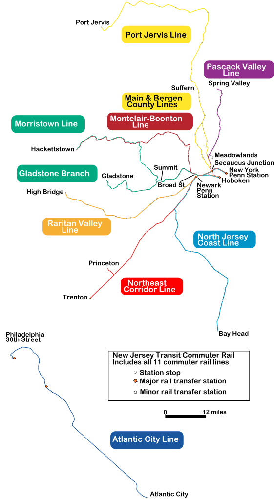
A map of New Jersey Transit's commuter rail routes; originally created by tracing a non-copyrighted NJDOT map in Inkscape. IMPORTANT: This is a version with only the terminal station names, designed for readability in an infobox. For the full map, see File:NJT railmap.svg. |
| Date | (UTC) |
| Source | |
| Author |
|
| This is a retouched picture, which means that it has been digitally altered from its original version. Modifications: removed stations; enlarged text for infobox readability. The original can be viewed here: NJT railmap.svg:
|
I, the copyright holder of this work, hereby publish it under the following licenses:

|
Permission is granted to copy, distribute and/or modify this document under the terms of the GNU Free Documentation License, Version 1.2 or any later version published by the Free Software Foundation; with no Invariant Sections, no Front-Cover Texts, and no Back-Cover Texts. A copy of the license is included in the section entitled GNU Free Documentation License. |
| This file is licensed under the Creative Commons Attribution-Share Alike 3.0 Unported license. | ||
| ||
| This licensing tag was added to this file as part of the GFDL licensing update. |
| I, the author of this work, hereby publish it under the following licenses: | ||||
This file is licensed under the Creative Commons Attribution-Share Alike 2.5 Generic license.
To provide attribution, credit the author as the uploader's username with a link to his userpage. You may select the license of your choice. |
You may select the license of your choice.
Original upload log edit
This image is a derivative work of the following images:
- File:NJT_railmap.svg licensed with GFDL, GFDL-CC-triple
- 2011-07-16T18:36:31Z Pi.1415926535 2720x4960 (299161 Bytes) Corrected geographic route of Meadowlands Rail Line; changed Princeton Junction to official name
- 2010-01-15T00:49:17Z Mitchazenia 2720x4960 (299351 Bytes) Some cosmetics had some problems
- 2010-01-15T00:40:28Z Mitchazenia 2720x4960 (299841 Bytes) update for Great Notch, some cosmetics
- 2009-09-26T22:02:53Z Mitchazenia 2720x4960 (302541 Bytes) Meadowlands
- 2009-09-20T21:48:49Z Mitchazenia 2720x4960 (302590 Bytes) fix
- 2009-09-19T13:35:37Z Mitchazenia 2720x4960 (301926 Bytes) Upload with 1. Removal of Finderne station 2. Adding of Wayne-Route 23 3. Adding of Meadowlands Rail Station 4. Adding of Mount Arlington Rail Station 5. Signed name of Princeton Junction
- 2009-09-19T02:47:06Z Oknazevad 2720x4960 (299946 Bytes) Reverted to version as of 20:12, 5 August 2006, new map of limited interest, prone to crystal balling
- 2009-09-19T01:38:28Z Mitchazenia 2720x4960 (3561101 Bytes) :|
- 2009-09-19T01:35:28Z Mitchazenia 2720x4960 (3561101 Bytes) Changes since August 2006 :|
- 2006-08-05T20:12:46Z Lensovet 2720x4960 (299946 Bytes) make lines significantly thicker; enlarge legend
- 2006-08-05T08:07:57Z Lensovet 2720x4960 (299425 Bytes) fix station legend
- 2006-08-05T07:59:56Z Lensovet 2720x4960 (299491 Bytes) A map of [[w:NJ Transit|]]'s commuter rail routes. Created by me by tracing over a non-copyrighted [[w:NJDOT|]] railroads map in Inkscape. ==Licensing== {{lensovet}} [[Category:Maps of New Jersey]] [[Category:New Jersey Tra
Uploaded with derivativeFX
File history
Click on a date/time to view the file as it appeared at that time.
| Date/Time | Thumbnail | Dimensions | User | Comment | |
|---|---|---|---|---|---|
| current | 23:34, 9 November 2011 | | 2,720 × 4,960 (768 KB) | Train2104 (talk | contribs) | Text to path, remove purple border, minor text placement changes |
| 18:46, 22 July 2011 |  | 2,720 × 4,960 (158 KB) | Pi.1415926535 (talk | contribs) | Even more spacing. Added a white background. | |
| 18:44, 22 July 2011 |  | 2,720 × 4,960 (158 KB) | Pi.1415926535 (talk | contribs) | More text spacing | |
| 21:29, 20 July 2011 |  | 2,720 × 4,960 (186 KB) | Pi.1415926535 (talk | contribs) | More text spacing | |
| 21:27, 20 July 2011 |  | 2,720 × 4,960 (186 KB) | Pi.1415926535 (talk | contribs) | Fixed text and spacing | |
| 21:13, 20 July 2011 |  | 2,720 × 4,960 (187 KB) | Pi.1415926535 (talk | contribs) | Adjusted color boxes to fit wikimedia rendering; Port Jervis Line color box; added Meadowlands, Secaucus, Broad St., Suffern, Summit stations. Removed River LINE. | |
| 19:36, 16 July 2011 |  | 2,720 × 4,960 (190 KB) | Pi.1415926535 (talk | contribs) | {{Information |Description=A map of New Jersey Transit's commuter rail routes; originally created by tracing a non-copyrighted NJDOT map in Inkscape. IMPORTANT: This is a version with only the terminal station names, designed for readability in an infob |
You cannot overwrite this file.
File usage on Commons
The following 2 pages use this file:
File usage on other wikis
The following other wikis use this file:
- Usage on en.wikipedia.org
- Usage on es.wikipedia.org
- Usage on id.wikipedia.org
- Usage on ja.wikipedia.org
- Usage on sv.wikipedia.org
- Usage on www.wikidata.org
- Usage on zh.wikipedia.org