File:NOMAD railway map (east part).png

Size of this preview: 800 × 496 pixels. Other resolutions: 320 × 198 pixels | 640 × 396 pixels | 1,024 × 634 pixels | 1,280 × 793 pixels | 3,200 × 1,982 pixels.
Original file (3,200 × 1,982 pixels, file size: 426 KB, MIME type: image/png)
Captions
Captions
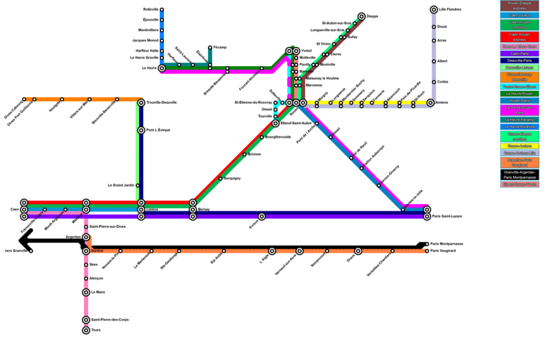
Map of the eastern part of Normandy railway network (NOMAD)
Summary edit
.png&action=edit§ion=1)
| Description |
English: Detailed map of all railway stations and lines in use in eastern Normandy as of May 2020. All the trains may not call at every station, depending on time.
Français : Plan détaillé de toutes les lignes et gares ferroviaires en service dans l'est de la Normandie et faisant partie du réseau NOMAD en mai 2020. Tous les trains ne s'arrêtent pas systématiquement à toutes les gares. |
| Date | |
| Source | Own work |
| Author | VinceSup |
Created with Metro Map Maker - source: https://metromapmaker.com/?map=0G4JcYG3
Licensing edit
.png&action=edit§ion=2)
I, the copyright holder of this work, hereby publish it under the following license:
| This file is made available under the Creative Commons CC0 1.0 Universal Public Domain Dedication. | |
| The person who associated a work with this deed has dedicated the work to the public domain by waiving all of their rights to the work worldwide under copyright law, including all related and neighboring rights, to the extent allowed by law. You can copy, modify, distribute and perform the work, even for commercial purposes, all without asking permission.
|
File history
Click on a date/time to view the file as it appeared at that time.
| Date/Time | Thumbnail | Dimensions | User | Comment | |
|---|---|---|---|---|---|
| current | 22:08, 22 May 2020 | | 3,200 × 1,982 (426 KB) | VinceSup (talk | contribs) | Uploaded own work with UploadWizard |
You cannot overwrite this file.
File usage on Commons
There are no pages that use this file.
.png&oldid=675372079)