File:NOS Chart Catalog-Bahamas Bermuda-Graphic.jpg
Size of this preview: 800 × 566 pixels. Other resolutions: 320 × 226 pixels | 640 × 453 pixels | 1,024 × 724 pixels | 1,280 × 906 pixels | 2,560 × 1,811 pixels | 4,529 × 3,204 pixels.
Original file (4,529 × 3,204 pixels, file size: 1.07 MB, MIME type: image/jpeg)
Captions
Captions
Add a one-line explanation of what this file represents
Summary
edit
| Description |
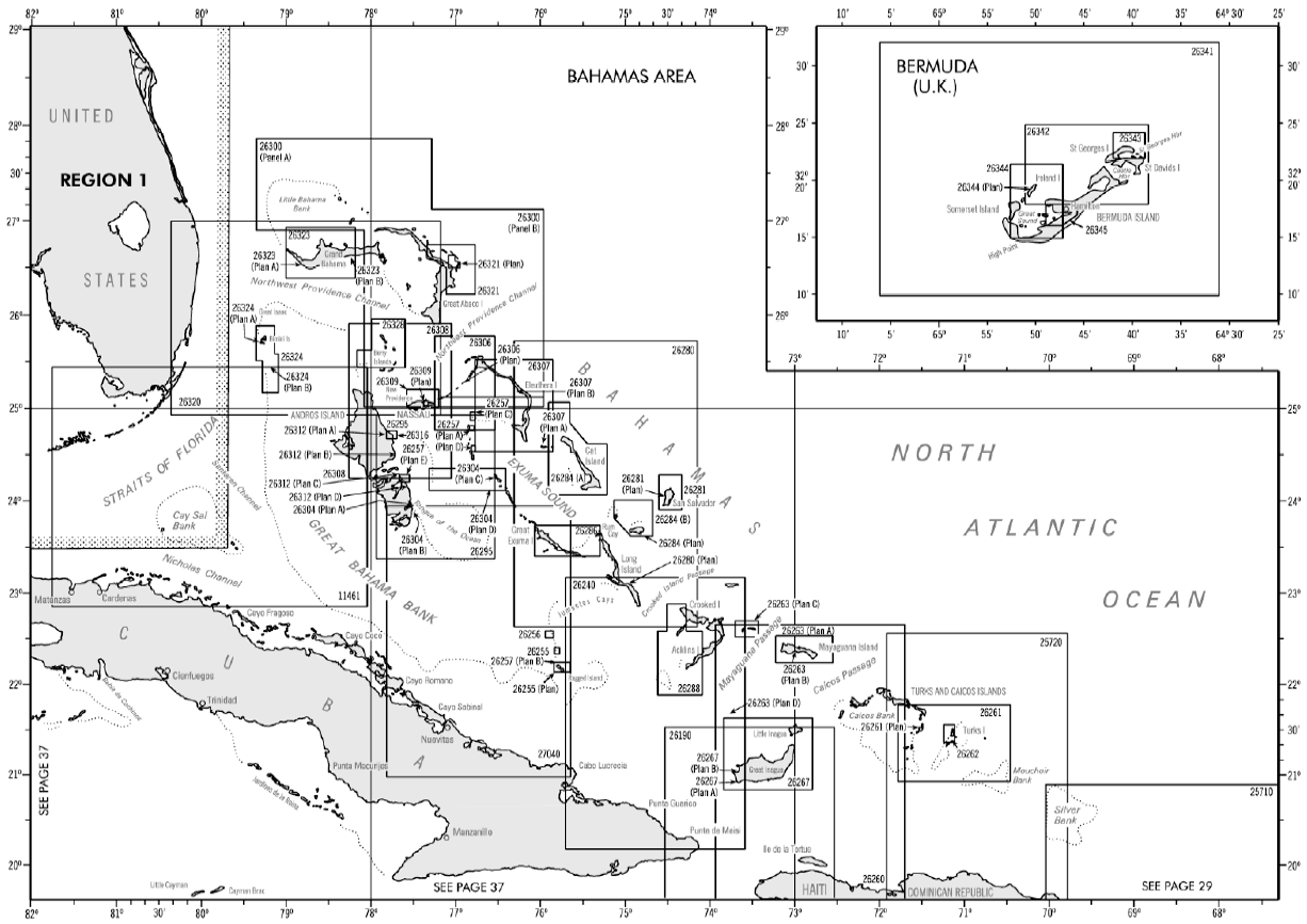
English: On catalogs NGA Nautical Charts are broken down into 9 Regions. Each Region in turn is divided in several sectors regarding Sailing Directions areas. In those areas are displayed the numbers of the charts and their coverage.
Español: En los catálogos las cartas editadas por la NGA están separadas en 9 regiones. Cada Región se divide a su vez en varios sectores acordes a las áreas abarcadas por lsa Sailing Directions. En esos sectores se muestra el número de todas las cartas correspondientes y las areas que cubren. |
| Date | |
| Source | http://avn.faa.gov/index.asp?xml=naco/catalog |
| Author | National Geospatial-Intelligence Agency (NGA) |
Licensing
edit
This work is in the public domain in the United States because it is a work prepared by an officer or employee of the United States Government as part of that person’s official duties under the terms of Title 17, Chapter 1, Section 105 of the US Code.
Note: This only applies to original works of the Federal Government and not to the work of any individual U.S. state, territory, commonwealth, county, municipality, or any other subdivision. This template also does not apply to postage stamp designs published by the United States Postal Service since 1978. (See § 313.6(C)(1) of Compendium of U.S. Copyright Office Practices). It also does not apply to certain US coins; see The US Mint Terms of Use.
|
 | |
| This file has been identified as being free of known restrictions under copyright law, including all related and neighboring rights. | ||
File history
Click on a date/time to view the file as it appeared at that time.
| Date/Time | Thumbnail | Dimensions | User | Comment | |
|---|---|---|---|---|---|
| current | 22:38, 8 November 2009 | | 4,529 × 3,204 (1.07 MB) | Audih (talk | contribs) | {{Information |Description={{en|1=On catalogs NGA Nautical Charts are broken down into 9 Regions. Each Region in turn is divided in several sectors regarding Sailing Directions areas. In those areas are displayed the numbers of the charts and their covera |
You cannot overwrite this file.
File usage on Commons
There are no pages that use this file.