File:NPS internment-camp-map.gif

Size of this preview: 795 × 600 pixels. Other resolutions: 318 × 240 pixels | 636 × 480 pixels | 884 × 667 pixels.
Original file (884 × 667 pixels, file size: 114 KB, MIME type: image/gif, 0.1 s)
Captions
Captions
Add a one-line explanation of what this file represents
Summary
edit
| Description |
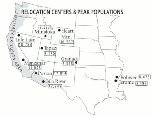
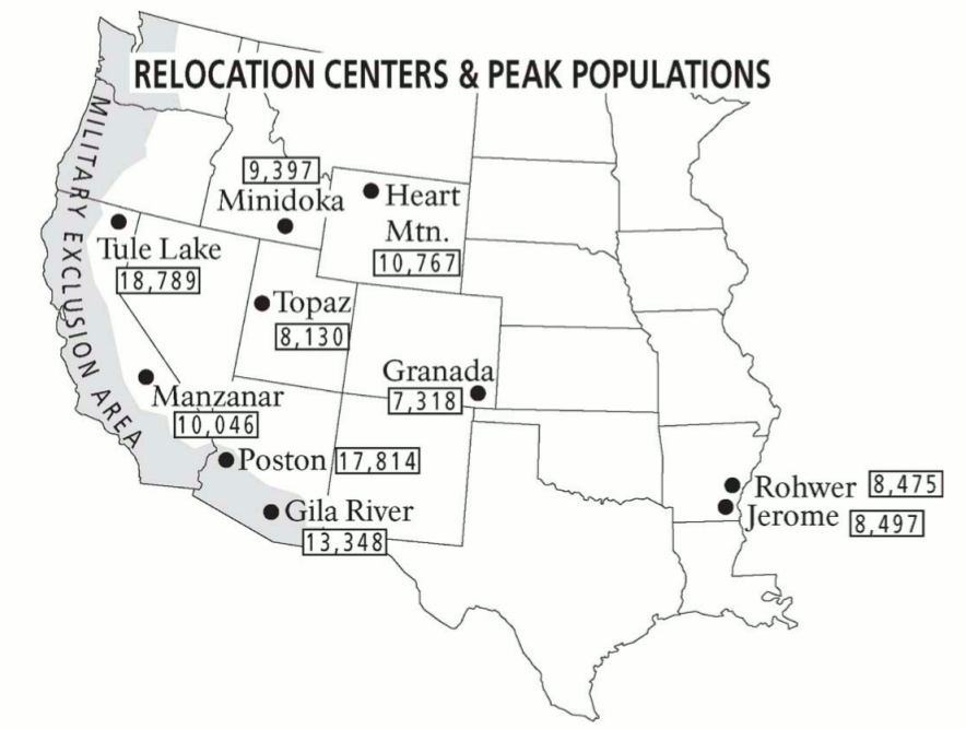
English: United States internment camp map, showing the other internment camps in use during World War II along with their peak populations. You can see that several were even larger than Manzanar. |
| Date | |
| Source | U.S. National Park Service (http://npmaps.com/wp-content/uploads/internment-camp-map.gif) |
| Author | U.S. National Park Service, restoration/cleanup by Matt Holly |
Licensing
edit
| This image or media file contains material based on a work of a National Park Service employee, created as part of that person's official duties. As a work of the U.S. federal government, such work is in the public domain in the United States. See the NPS website and NPS copyright policy for more information. |
File history
Click on a date/time to view the file as it appeared at that time.
| Date/Time | Thumbnail | Dimensions | User | Comment | |
|---|---|---|---|---|---|
| current | 00:59, 17 May 2017 | | 884 × 667 (114 KB) | RKBot (talk | contribs) | =={{int:filedesc}}== {{Information |description= {{en|1=United States internment camp map, showing the other internment camps in use during World War II along with their peak populations. You can see that several were even larger than Manzanar.}} |date... |
You cannot overwrite this file.
File usage on Commons
The following page uses this file: