File:NPS petrified-forest-regional-map.jpg

No higher resolution available.
NPS_petrified-forest-regional-map.jpg (788 × 436 pixels, file size: 55 KB, MIME type: image/jpeg)
Captions
Captions
Add a one-line explanation of what this file represents
Summary
edit
| Description |
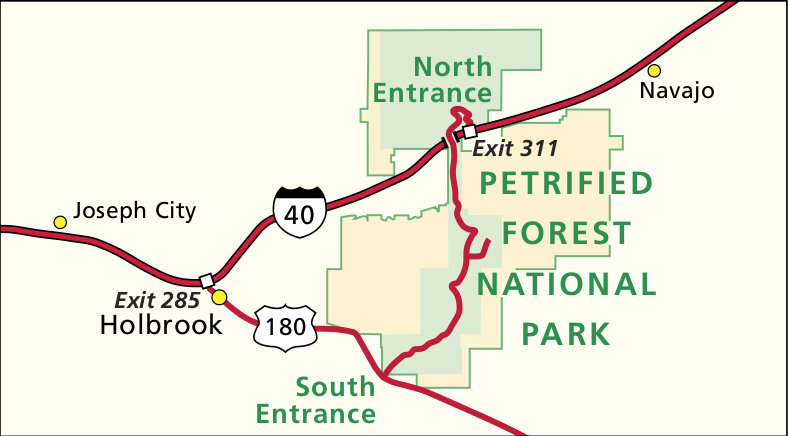
English: Regional map of Petrified Forest, showing nearby highways, towns, and both the north and south entrances. |
| Date | |
| Source | U.S. National Park Service (http://npmaps.com/wp-content/uploads/petrified-forest-regional-map.jpg) |
| Author | U.S. National Park Service, restoration/cleanup by Matt Holly |
| Other versions |
 |
Licensing
edit
| This image or media file contains material based on a work of a National Park Service employee, created as part of that person's official duties. As a work of the U.S. federal government, such work is in the public domain in the United States. See the NPS website and NPS copyright policy for more information. |
File history
Click on a date/time to view the file as it appeared at that time.
| Date/Time | Thumbnail | Dimensions | User | Comment | |
|---|---|---|---|---|---|
| current | 01:49, 17 May 2017 | | 788 × 436 (55 KB) | RKBot (talk | contribs) | =={{int:filedesc}}== {{Information |description= {{en|1=Regional map of Petrified Forest, showing nearby highways, towns, and both the north and south entrances.}} |date= 2014-03-23 |source= U.S. National Park Service (http://npmaps.com/wp-content/uplo... |
You cannot overwrite this file.
File usage on Commons
The following 2 pages use this file: