File:NY 52 profile.png

Size of this preview: 800 × 330 pixels. Other resolutions: 320 × 132 pixels | 640 × 264 pixels | 1,233 × 508 pixels.
Original file (1,233 × 508 pixels, file size: 23 KB, MIME type: image/png)
Captions
Captions
Add a one-line explanation of what this file represents
Summary
edit
| Description |
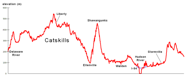
This is an elevation profile of New York State Route 52. The GIS data used was U.S. Census TIGER/Line data (for the road) and USGS Digital Elevation Model data.
|
| Date | 24 June 2007 (original upload date) |
| Source | No machine-readable source provided. Own work assumed (based on copyright claims). |
| Author | No machine-readable author provided. NE2 assumed (based on copyright claims). |
Licensing
edit
| This work has been released into the public domain by its author, I, NE2. This applies worldwide. In some countries this may not be legally possible; if so: I, NE2 grants anyone the right to use this work for any purpose, without any conditions, unless such conditions are required by law. |
File history
Click on a date/time to view the file as it appeared at that time.
| Date/Time | Thumbnail | Dimensions | User | Comment | |
|---|---|---|---|---|---|
| current | 05:32, 24 June 2007 | 1,233 × 508 (23 KB) | NE2 (talk | contribs) | Unbolded the text. | |
| 05:28, 24 June 2007 | 1,233 × 508 (23 KB) | NE2 (talk | contribs) | This is an elevation profile of New York State Route 52. The GIS data used was U.S. Census TIGER/Line data (for the road) and USGS Digital Elevation Model data. *The image is not in SVG because ArcMap cannot export an elevation profile as SVG. *There is n |
You cannot overwrite this file.
File usage on Commons
There are no pages that use this file.