File:NY Congressional Districts 110th Congress.png

Size of this preview: 709 × 600 pixels. Other resolutions: 284 × 240 pixels | 567 × 480 pixels | 908 × 768 pixels | 1,210 × 1,024 pixels | 2,457 × 2,079 pixels.
Original file (2,457 × 2,079 pixels, file size: 1.16 MB, MIME type: image/png)
Captions
Captions
Add a one-line explanation of what this file represents
Summary edit
| Description |
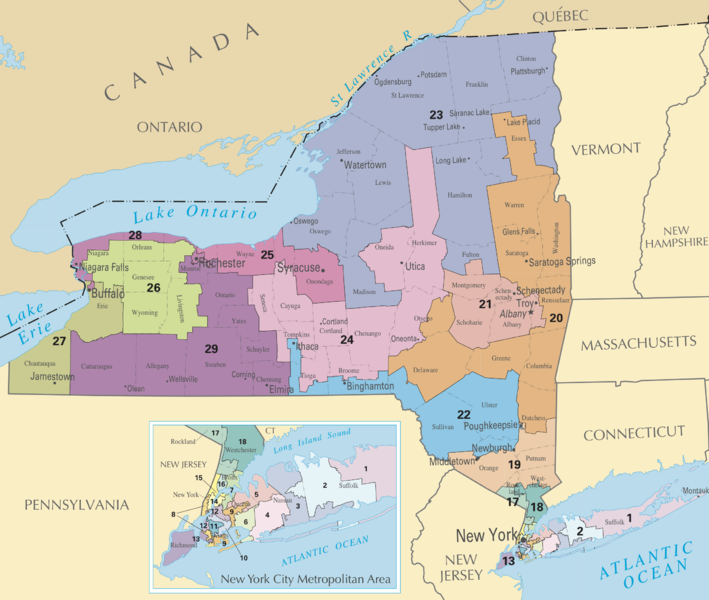
English: Map of New York's congressional districts from 2003 to present. |
| Date | |
| Source | Printable maps: New York. National Atlas of the United States. United States Department of the Interior. Retrieved on 2009-09-06. |
| Author | United States Department of the Interior |
| This is a retouched picture, which means that it has been digitally altered from its original version. Modifications: cropped from the original; transferred into PNG from PDF. Modifications made by UpstateNYer.
|
Licensing edit
This map was obtained from an edition of the National Atlas of the United States. Like almost all works of the U.S. federal government, works from the National Atlas are in the public domain in the United States.
Online access: NationalAtlas.gov | 1970 print edition: Library of Congress, Perry-Castañeda Library
|
File history
Click on a date/time to view the file as it appeared at that time.
| Date/Time | Thumbnail | Dimensions | User | Comment | |
|---|---|---|---|---|---|
| current | 00:26, 7 September 2009 | | 2,457 × 2,079 (1.16 MB) | MattWade (talk | contribs) | {{Information |Description={{en|1=Map of en:New York's congressional districts from 2003 to present.}} |Source={{cite web |title=Printable maps: New York |url=http://www.nationalatlas.gov/printable/images/pdf/congdist/pagecgd110_ny.pdf |publisher=[[ |
You cannot overwrite this file.
File usage on Commons
There are no pages that use this file.
File usage on other wikis
The following other wikis use this file:
- Usage on en.wikipedia.org
- Usage on ru.wikipedia.org