File:NY Route 404 map.svg

Size of this PNG preview of this SVG file: 800 × 474 pixels. Other resolutions: 320 × 190 pixels | 640 × 380 pixels | 1,024 × 607 pixels | 1,280 × 759 pixels | 2,560 × 1,518 pixels | 1,450 × 860 pixels.
Original file (SVG file, nominally 1,450 × 860 pixels, file size: 574 KB)
Captions
Captions
Add a one-line explanation of what this file represents
Summary
edit
| Description |
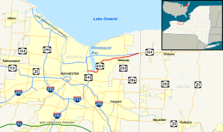
English: Map of New York State Route 404. Base map made in Quantum GIS using GIS data from the United States Census Bureau (TIGER) and the Federal Highway Administration (NHPN), and enhanced using Inkscape. This map uses public domain SVG route markers available on Wikimedia Commons. |
| Date | |
| Source | Own work |
| Author | TwinsMetsFan |
| SVG development |
Licensing
edit
| I, the copyright holder of this work, release this work into the public domain. This applies worldwide. In some countries this may not be legally possible; if so: I grant anyone the right to use this work for any purpose, without any conditions, unless such conditions are required by law. |
File history
Click on a date/time to view the file as it appeared at that time.
| Date/Time | Thumbnail | Dimensions | User | Comment | |
|---|---|---|---|---|---|
| current | 05:58, 11 February 2011 | | 1,450 × 860 (574 KB) | TwinsMetsFan (talk | contribs) | {{Information |Description ={{en|1=Map of New York State Route 404. Base map made in Quantum GIS using GIS data from the United States Census Bureau ([http://arcdata.esri.com/data/tiger2000/tiger_download.cfm TIGER]) an |
You cannot overwrite this file.
File usage on Commons
The following page uses this file:
File usage on other wikis
The following other wikis use this file:
- Usage on en.wikipedia.org
- Usage on www.wikidata.org