File:NZ-TeAtatu.png

Size of this preview: 504 × 600 pixels. Other resolutions: 202 × 240 pixels | 589 × 701 pixels.
Original file (589 × 701 pixels, file size: 104 KB, MIME type: image/png)
Captions
Captions
Add a one-line explanation of what this file represents
| Description |
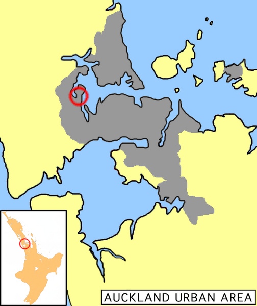
English: Location map of Te Atatu, New Zealand |
| Date | 13 December 2005 (original upload date) |
| Source | Transferred from en.wikipedia to Commons. |
| Author | Grutness at English Wikipedia |
Licensing
edit
| This work has been released into the public domain by its author, Grutness at English Wikipedia. This applies worldwide. In some countries this may not be legally possible; if so: Grutness grants anyone the right to use this work for any purpose, without any conditions, unless such conditions are required by law. |
Original upload log
edit
The original description page was here. All following user names refer to en.wikipedia.
- 2005-12-13 06:12 Grutness 589×701× (106865 bytes) Location map of Te Atatu, New Zealand {{pd-self}}
File history
Click on a date/time to view the file as it appeared at that time.
| Date/Time | Thumbnail | Dimensions | User | Comment | |
|---|---|---|---|---|---|
| current | 00:10, 27 March 2009 | | 589 × 701 (104 KB) | Kordas (talk | contribs) | {{Information |Description={{en|Location map of Te Atatu, New Zealand}} |Source=Transferred from [http://en.wikipedia.org en.wikipedia] |Date=2005-12-13 (original upload date) |Author=Original uploader was Grutness at [http://en.wiki |
You cannot overwrite this file.
File usage on Commons
There are no pages that use this file.