File:NZTerritorialAuthorities.png
Size of this preview: 458 × 600 pixels. Other resolutions: 183 × 240 pixels | 366 × 480 pixels | 872 × 1,142 pixels.
Original file (872 × 1,142 pixels, file size: 68 KB, MIME type: image/png)
Captions
Captions
Territorial authorities of New Zealand
Summary edit
| Description |
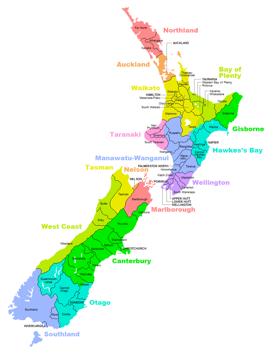
English: Map of territorial authorities (regions, districts, municipalities, etc) in New Zealand |
| Date | |
| Source | Own work |
| Author | Vardion |
| Other versions | Derivative works of this file: NZTerritorialAuthorities-Waikato.png |
Licensing edit
I, the copyright holder of this work, hereby publish it under the following licenses:

|
Permission is granted to copy, distribute and/or modify this document under the terms of the GNU Free Documentation License, Version 1.2 or any later version published by the Free Software Foundation; with no Invariant Sections, no Front-Cover Texts, and no Back-Cover Texts. A copy of the license is included in the section entitled GNU Free Documentation License. |
This file is licensed under the Creative Commons Attribution-Share Alike 3.0 Unported, 2.5 Generic, 2.0 Generic and 1.0 Generic license.
- You are free:
- to share – to copy, distribute and transmit the work
- to remix – to adapt the work
- Under the following conditions:
- attribution – You must give appropriate credit, provide a link to the license, and indicate if changes were made. You may do so in any reasonable manner, but not in any way that suggests the licensor endorses you or your use.
- share alike – If you remix, transform, or build upon the material, you must distribute your contributions under the same or compatible license as the original.
You may select the license of your choice.
File history
Click on a date/time to view the file as it appeared at that time.
| Date/Time | Thumbnail | Dimensions | User | Comment | |
|---|---|---|---|---|---|
| current | 18:52, 18 November 2012 | | 872 × 1,142 (68 KB) | Teemu Leisti (talk | contribs) | I accidentally uploaded the previous version of the file when I meant to provide this updated version. The origin is http://s15.postimage.org/r30sygnaj/NZTerritorial_Authorities2010.png. |
| 18:49, 18 November 2012 |  | 872 × 1,142 (68 KB) | Teemu Leisti (talk | contribs) | Updated according to the situation in November 2012, as requested by an anonymous user who made the request to me [http://en.wikipedia.org/w/index.php?title=User_talk:Teemu_Leisti&oldid=521122589 on my talk page]. | |
| 21:19, 22 September 2007 |  | 872 × 1,142 (68 KB) | Vardion (talk | contribs) | {{Information |Description=Map of territorial authorities (regions, districts, municipalities, etc) in New Zealand |Source=Self-made |Date=23 September 2007 |Author=Uploader |Permission= |other_versions= }} |
You cannot overwrite this file.
File usage on Commons
The following 2 pages use this file:
File usage on other wikis
The following other wikis use this file:
- Usage on ace.wikipedia.org
- Usage on ar.wikipedia.org
- Usage on ary.wikipedia.org
- Usage on ca.wikipedia.org
- Usage on cs.wikipedia.org
- Usage on cv.wikipedia.org
- Usage on es.wikipedia.org
- Usage on fr.wikipedia.org
- Dunedin
- Wellington
- Auckland
- Gisborne (région)
- Waitakere
- Christchurch
- Napier (Nouvelle-Zélande)
- Queenstown (Nouvelle-Zélande)
- New Plymouth
- Invercargill
- Îles Chatham
- Hamilton (Nouvelle-Zélande)
- Rotorua
- Taupo
- Tauranga
- Whangarei
- Modèle:Palette Autorité territoriale de Nouvelle-Zélande
- Autorité territoriale
- Ashburton (Nouvelle-Zélande)
- Masterton
- Catégorie:Subdivision en Nouvelle-Zélande
- Tasman (région)
- Gisborne (Nouvelle-Zélande)
- Marlborough (Nouvelle-Zélande)
- Nelson (région)
- Wanganui
- Palmerston North
- Timaru (Nouvelle-Zélande)
- Whakatane
- Kaikoura
- North Shore City
- Manukau City
- Porirua
- Upper Hutt
- Lower Hutt
- District du Far North
- District de Kaipara
- District de Rodney
- District de Papakura
View more global usage of this file.