File:Nagaland district map.svg

Size of this PNG preview of this SVG file: 677 × 599 pixels. Other resolutions: 271 × 240 pixels | 542 × 480 pixels | 867 × 768 pixels | 1,157 × 1,024 pixels | 2,313 × 2,048 pixels | 768 × 680 pixels.
Original file (SVG file, nominally 768 × 680 pixels, file size: 610 KB)
Captions
Captions
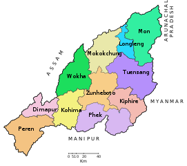
District map of the state of Nagaland, India
Summary
edit| Description |
Deutsch: Distrikteinteilung des indischen Bundesstaats Nagaland. English: District map of the State of Nagaland, India. |
||
| Date | |||
| Source |
This file was derived from: Nagalandmap.png |
||
| Author |
|
||
| Permission (Reusing this file) |
I, the copyright holder of this work, hereby publish it under the following licenses:
This file is licensed under the Creative Commons Attribution-Share Alike Attribution-Share Alike 4.0 International, 3.0 Unported, 2.5 Generic, 2.0 Generic and 1.0 Generic license.
You may select the license of your choice. |
||
| Other versions |
[]
|
||
| SVG development | This vector image was created with Adobe Illustrator. |


File history
Click on a date/time to view the file as it appeared at that time.
| Date/Time | Thumbnail | Dimensions | User | Comment | |
|---|---|---|---|---|---|
| current | 17:30, 21 January 2017 | | 768 × 680 (610 KB) | Furfur (talk | contribs) | == {{int:filedesc}} == {{Information |Description={{de|1=Distrikteinteilung des indischen Bundesstaats Nagaland.}}{{en|1= District map of the State of Nagaland, India.}} |Source={{Derived from|Nagalandmap.png}} |Date=2017-01-21 |Author=* [[:File:Nagala... |
You cannot overwrite this file.
File usage on Commons
The following 12 pages use this file:
- File:Nagaland district map-bh.svg
- File:Nagaland district map-gu.svg
- File:Nagaland district map-hi.svg
- File:Nagaland district map-kn.svg
- File:Nagaland district map-mr.svg
- File:Nagaland district map-pa.svg
- File:Nagaland district map-sat.svg
- File:Nagaland district map-te.svg
- File:Nagaland district map.svg
- File:Nagaland district map as.svg
- File:Nagaland district map ml.svg
- Template:Other versions/Nagaland district map.svg
File usage on other wikis
The following other wikis use this file:
- Usage on de.wikipedia.org
- Usage on sat.wikipedia.org