File:Nagasakiroad012map.jpg

Size of this preview: 345 × 599 pixels. Other resolutions: 138 × 240 pixels | 276 × 480 pixels | 442 × 768 pixels | 1,204 × 2,091 pixels.
Original file (1,204 × 2,091 pixels, file size: 256 KB, MIME type: image/jpeg)
Captions
Captions
Add a one-line explanation of what this file represents
Summary
edit
| Description |
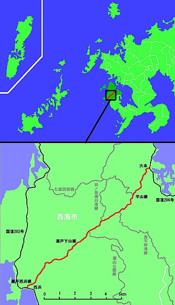
日本語: 日本語: 長崎県道12号大瀬戸西彼線の線形図 |
| Date | 2010年5月4日 |
| Source | 国土地理院1/25000地形図「板浦」を参照し投稿者作成 |
| Author | 水雷艇鷂 |
| Permission (Reusing this file) |
下記を参照 |
| I, the copyright holder of this work, release this work into the public domain. This applies worldwide. In some countries this may not be legally possible; if so: I grant anyone the right to use this work for any purpose, without any conditions, unless such conditions are required by law. |
File history
Click on a date/time to view the file as it appeared at that time.
| Date/Time | Thumbnail | Dimensions | User | Comment | |
|---|---|---|---|---|---|
| current | 06:09, 5 May 2010 | | 1,204 × 2,091 (256 KB) | 水雷艇鷂 (talk | contribs) | == {{int:filedesc}} == {{Information |Description={{ja|1=長崎県道・佐賀県道1号佐世保嬉野線の線形図}} |Source=国土地理院1/25000地形図「板浦」を参照し投稿者作成 |Author=水雷艇鷂 |Date=2010年5月4日 |Permission= |
You cannot overwrite this file.
File usage on Commons
There are no pages that use this file.
File usage on other wikis
The following other wikis use this file:
- Usage on ja.wikipedia.org