File:Nam-Viet 200bc.jpg
Size of this preview: 728 × 599 pixels. Other resolutions: 292 × 240 pixels | 583 × 480 pixels | 933 × 768 pixels | 1,166 × 960 pixels.
Original file (1,166 × 960 pixels, file size: 856 KB, MIME type: image/jpeg)
Captions
Captions
Add a one-line explanation of what this file represents

|
This historical map image could be re-created using vector graphics as an SVG file. This has several advantages; see Commons:Media for cleanup for more information. If an SVG form of this image is available, please upload it and afterwards replace this template with
{{vector version available|new image name}}.
It is recommended to name the SVG file “Nam-Viet 200bc.svg”—then the template Vector version available (or Vva) does not need the new image name parameter. |


Summary edit
| Description |
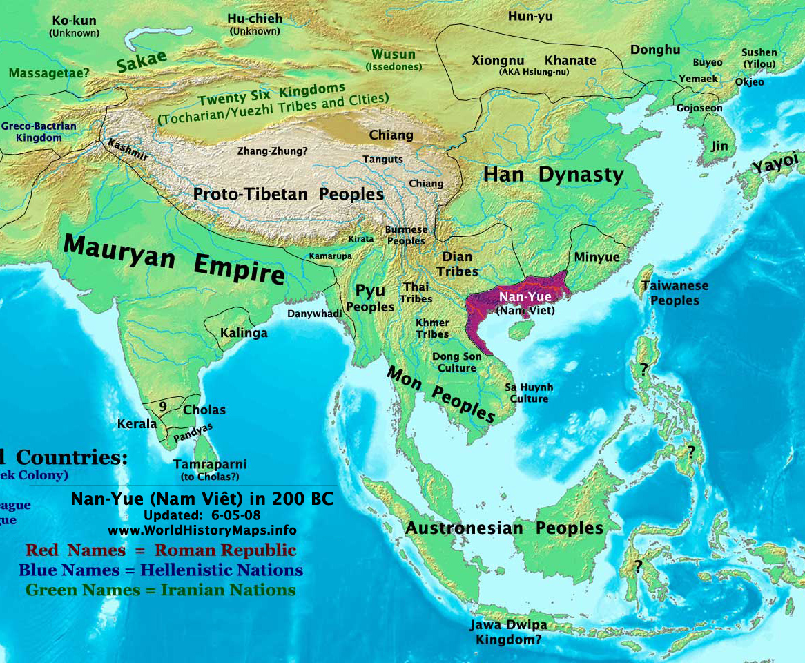
English: Map of ancient Nam Việt (204 BCE - 111 BCE) - an ancient kingdom that consisted of parts of the modern southern Chinese provinces of Guangdong, Guangxi, Yunnan and northern Vietnam.
|
| Date | 10 July 2009 (original upload date) |
| Source | Transferred from en.wikipedia to Commons by Alagos. |
| Author | The original uploader was Sea888 at English Wikipedia. |
Licensing edit
This file is licensed under the Creative Commons Attribution-Share Alike 3.0 Unported license.
- You are free:
- to share – to copy, distribute and transmit the work
- to remix – to adapt the work
- Under the following conditions:
- attribution – You must give appropriate credit, provide a link to the license, and indicate if changes were made. You may do so in any reasonable manner, but not in any way that suggests the licensor endorses you or your use.
- share alike – If you remix, transform, or build upon the material, you must distribute your contributions under the same or compatible license as the original.
Original upload log edit
The original description page was here. All following user names refer to en.wikipedia.
Upload date | User | Bytes | Dimensions | Comment
- 2009-07-10 19:33:35 | Sea888 | 876342 | 1166×960 | Author: Thomas A. Lessman. Source URL: http://www.worldhistorymaps.info/maps.html. Image was created by me (Thomas Lessman) based on map of Eastern Hemisphere in 200 BC. Image is free for public and/or educational use. I would appreciate a mention if this
File history
Click on a date/time to view the file as it appeared at that time.
| Date/Time | Thumbnail | Dimensions | User | Comment | |
|---|---|---|---|---|---|
| current | 15:27, 5 January 2013 | | 1,166 × 960 (856 KB) | Alagos (talk | contribs) | {{CH2MoveToCommons|en.wikipedia|year={{subst:CURRENTYEAR}}|month={{subst:CURRENTMONTHNAME}}|day={{subst:CURRENTDAY}}}} The tool and the bot are operated by User:Jan Luca and User:Magnus Manske. =={{int:filedesc}}== {{Information |description=A... |
You cannot overwrite this file.
File usage on Commons
There are no pages that use this file.
File usage on other wikis
The following other wikis use this file:
- Usage on ast.wikipedia.org
- Usage on bcl.wikipedia.org
- Usage on bn.wikipedia.org
- Usage on en.wikipedia.org
- Usage on es.wikipedia.org
- Usage on eu.wikipedia.org
- Usage on fi.wikipedia.org
- Usage on fr.wikipedia.org
- Usage on id.wikipedia.org
- Usage on ja.wikipedia.org
- Usage on pnb.wikipedia.org
- Usage on pt.wikipedia.org
- Usage on ru.wikipedia.org
- Usage on th.wikipedia.org
- Usage on uk.wikipedia.org
- Usage on ur.wikipedia.org
- Usage on vi.wikipedia.org