File:Nansen Fram Map rus.png
Size of this preview: 800 × 479 pixels. Other resolutions: 320 × 192 pixels | 640 × 383 pixels | 1,003 × 601 pixels.
Original file (1,003 × 601 pixels, file size: 84 KB, MIME type: image/png)
Captions
Captions
Add a one-line explanation of what this file represents
| Description |
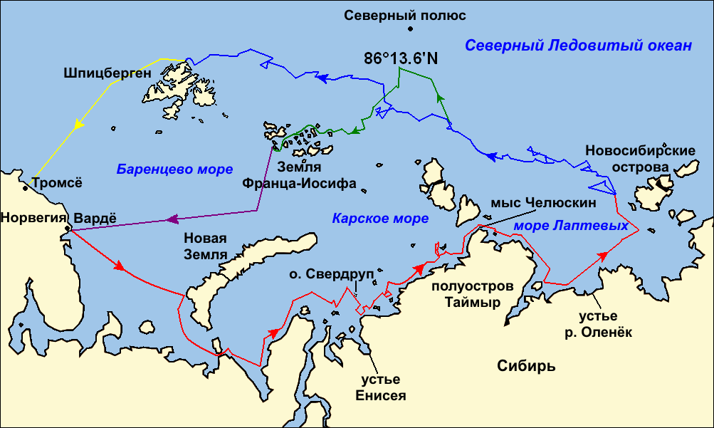
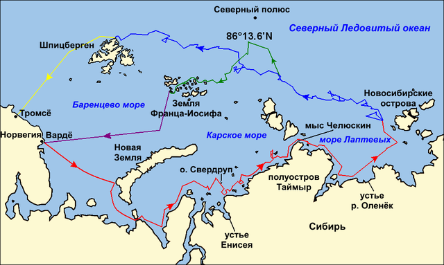
Map of the Arctic Ocean showing the routes taken during the 1893–96 Nansen's Fram expedition: Frams's route eastward from Vardø to the Siberian coast, turning north at the New Siberian Islands to enter the pack ice. July – September 1893 Fram's drift in the ice from the New Siberian Islands, north and west to Spitsbergen, September 1893 – August 1896 Nansen and Johansen's march to Farthest North, 80°20'N, and their subsequent retreat to Cape Flora in Franz Josef Land. February 1895 – June 1896 Nansen and Johansen's return to Vardø from Cape Flora, August 1896 Fram's voyage from Spitsbergen to Tromsø, August 1896 |
| Date | (UTC) |
| Source | |
| Author |
|
| Other versions |
|

| This is a retouched picture, which means that it has been digitally altered from its original version. Modifications: текст на русском языке (russian text). The original can be viewed here: Nansen Fram Map.png:
|
I, the copyright holder of this work, hereby publish it under the following licenses:
This file is licensed under the Creative Commons Attribution-Share Alike 3.0 Unported, 2.5 Generic, 2.0 Generic and 1.0 Generic license.
- You are free:
- to share – to copy, distribute and transmit the work
- to remix – to adapt the work
- Under the following conditions:
- attribution – You must give appropriate credit, provide a link to the license, and indicate if changes were made. You may do so in any reasonable manner, but not in any way that suggests the licensor endorses you or your use.
- share alike – If you remix, transform, or build upon the material, you must distribute your contributions under the same or compatible license as the original.

|
Permission is granted to copy, distribute and/or modify this document under the terms of the GNU Free Documentation License, Version 1.2 or any later version published by the Free Software Foundation; with no Invariant Sections, no Front-Cover Texts, and no Back-Cover Texts. A copy of the license is included in the section entitled GNU Free Documentation License. |
You may select the license of your choice.
Original upload log edit
This image is a derivative work of the following images:
- File:Nansen_Fram_Map.png licensed with Cc-by-sa-3.0,2.5,2.0,1.0, GFDL
- 2009-10-21T15:50:57Z Ruhrfisch 1003x601 (79935 Bytes) Make arrowheads less triangular (indentations at rear)
- 2009-10-21T15:23:20Z Ruhrfisch 1003x601 (79868 Bytes) Add arrowheads per FAC
- 2009-10-20T18:50:18Z Ruhrfisch 1003x601 (79825 Bytes) Make magenta line purple
- 2009-10-11T13:36:40Z Ruhrfisch 1003x601 (79831 Bytes) Yellow line for orange, some labels smaller, Farthest North replaced with actual figure, all other info the same
- 2009-10-11T03:08:59Z Ruhrfisch 1003x601 (81994 Bytes) Darker green for that line, all other information is the same
- 2009-10-11T02:46:31Z Ruhrfisch 1003x601 (81987 Bytes) Added last two lines for ice voyages, added last labels, all other information the same.
- 2009-10-09T19:30:04Z Ruhrfisch 1003x601 (75047 Bytes) Add labels, two more voyage lines, all other information is the same
- 2009-10-09T16:12:36Z Ruhrfisch 1003x601 (57897 Bytes) == Summary == {{Information |Description = Map of the Arctic Ocean showing the path of [[w:Nansen's Fram expedition|Nansen's Fram expedition]] 1893 to 1896 |Source = Base map of European mainland is from [[:File:Ma
Uploaded with derivativeFX
File history
Click on a date/time to view the file as it appeared at that time.
| Date/Time | Thumbnail | Dimensions | User | Comment | |
|---|---|---|---|---|---|
| current | 23:06, 8 January 2011 | | 1,003 × 601 (84 KB) | Ivengo(RUS) (talk | contribs) | {{Information |Description=Map of the Arctic Ocean showing the routes taken during the 1893–96 Nansen's Fram expedition: {{legend|red|Frams's route eastward from Vardø to the Siberian coast, turning north at the New Sibe |
You cannot overwrite this file.
File usage on Commons
The following page uses this file:
File usage on other wikis
The following other wikis use this file:
- Usage on ba.wikipedia.org
- Usage on be.wikipedia.org
- Usage on bg.wikipedia.org
- Usage on hy.wikipedia.org
- Usage on kk.wikipedia.org
- Usage on ru.wikipedia.org
- Usage on uk.wikipedia.org