File:Natsudomari Peninsula.png
No higher resolution available.
Natsudomari_Peninsula.png (618 × 537 pixels, file size: 356 KB, MIME type: image/png)
Captions
Captions
Add a one-line explanation of what this file represents
Summary
edit
| Description |
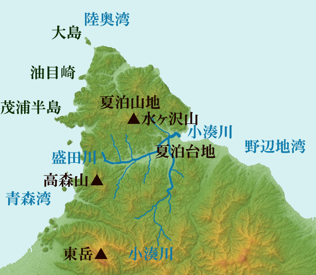
English: Labeled Topographical Map of the Natsudomari Peninsula with h
日本語: ja:夏泊半島関係の主な地形 |
| Date | |
| Source |
ja:c:Shimokita Peninsula Relief Map, SRTM-1.jpgをもとに作成(原著作者=Batholith (Wikimedia Commons) Batholith (Wikipedia)によるNASA's Shuttle Radar Topography Mission (SRTM-1 "30m Mesh")から作成の画像) |
| Author | ja:user:㭍月例祭 on Japanese Wikipedia + NASA |
| Other versions |
|
Licensing
edit
| This work has been released into the public domain by its author, 㭍月例祭 at Japanese Wikipedia. This applies worldwide. In some countries this may not be legally possible; if so: 㭍月例祭 grants anyone the right to use this work for any purpose, without any conditions, unless such conditions are required by law. |
This image uses high-resolution digital topography data from NASA's Shuttle Radar Topography Mission (SRTM) at JPL-Caltech [1]. It is in the public domain in the United States.
|
 | |
Original upload log
edit
| This file was moved from Japanese Wikipedia.
See below for original file information. | ||||||||||||||||||||||||||||||||||||||||||||||||||||
| ||||||||||||||||||||||||||||||||||||||||||||||||||||
|
| ||||||||||||||||||||||||||||||||||||||||||||||||||||
File history
Click on a date/time to view the file as it appeared at that time.
| Date/Time | Thumbnail | Dimensions | User | Comment | |
|---|---|---|---|---|---|
| current | 02:30, 22 May 2020 | | 618 × 537 (356 KB) | Flalf (talk | contribs) | Uploaded a work by 㭍月例祭 on Japanese Wikipedia from Japanese Wikipedia with UploadWizard |
| 14:05, 10 May 2018 |  | 618 × 537 (356 KB) | 㭍月例祭 (talk | contribs) | ||
| 15:06, 5 May 2018 |  | 354 × 316 (97 KB) | 㭍月例祭 (talk | contribs) | ||
| 14:32, 5 May 2018 |  | 354 × 316 (95 KB) | 㭍月例祭 (talk | contribs) | ||
| 14:22, 5 May 2018 |  | 370 × 345 (102 KB) | 㭍月例祭 (talk | contribs) | {{Information |Description=夏泊半島関係の主な地形 |Source=c:Aomori-ken géolocalisation relief.svgを基に作成(原著作者=Bourrichon (atelier graphique))を基に作成 |Date=2018/05/05 |Location= |Author=㭍月例祭 |Permission={{PD-self}} |other_versions= }} |
You cannot overwrite this file.
File usage on Commons
The following 2 pages use this file:
- File:夏泊半島概略図.png (file redirect)
- Category:Natsudomari Peninsula
File usage on other wikis
The following other wikis use this file: