File:Naturraumuebersicht Marburger Bergland.jpg

Size of this preview: 328 × 598 pixels. Other resolutions: 131 × 240 pixels | 263 × 480 pixels | 421 × 768 pixels | 1,248 × 2,276 pixels.
Original file (1,248 × 2,276 pixels, file size: 629 KB, MIME type: image/jpeg)
Captions
Captions
Add a one-line explanation of what this file represents
Summary
edit
| Description |
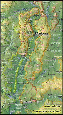
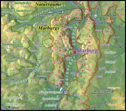
Deutsch: Naturraumübersicht zum Marburger Bergland mit dem Marburger Rücken westlich und den Lahnbergen östlich des Lahntals. Naturraumgrenzen: Dunkelgrün für Grundgebirge, Rot für Buntsandstein, Orange für Basalt und Graugrün für Quartär sowie Hügelland und Senken. English: Valley of river Lahn in Hesse around of Marburg. Mountain ridge Marburger Rücken with Hasenkopf (Marburger Rücken) West of the valley, Lahnberge in the East of the valley. |
| Date | |
| Source |
Own work /
|
| Author | Elop, Relief: https://maps-for-free.com/ maps-for-free] |
| Other versions |
        |
Licensing
edit
I, the copyright holder of this work, hereby publish it under the following license:
This file is licensed under the Creative Commons Attribution-Share Alike 3.0 Unported license.
- You are free:
- to share – to copy, distribute and transmit the work
- to remix – to adapt the work
- Under the following conditions:
- attribution – You must give appropriate credit, provide a link to the license, and indicate if changes were made. You may do so in any reasonable manner, but not in any way that suggests the licensor endorses you or your use.
- share alike – If you remix, transform, or build upon the material, you must distribute your contributions under the same or compatible license as the original.
File history
Click on a date/time to view the file as it appeared at that time.
| Date/Time | Thumbnail | Dimensions | User | Comment | |
|---|---|---|---|---|---|
| current | 22:23, 7 May 2024 | | 1,248 × 2,276 (629 KB) | Elop (talk | contribs) | |
| 12:55, 7 May 2024 |  | 1,248 × 2,276 (630 KB) | Elop (talk | contribs) | ||
| 12:05, 7 September 2021 |  | 1,248 × 2,234 (598 KB) | Elop (talk | contribs) | OSM-Grenzen waren oft fehlerhaft; + Gemarkungen, Pfaffenwald geologisch hervorgehoben et al | |
| 15:07, 3 September 2021 |  | 1,248 × 2,234 (578 KB) | Elop (talk | contribs) | == {{int:filedesc}} == {{Information |Description ={{de|1= Naturraumübersicht zum Marburger Bergland mit Marburger Rücken und Lahnbergen }} |Source ={{own}} / * * Gerhard Sandner: ''Geographische Landesaufnahme: Die naturräumlichen Einheiten auf Blatt 125 Marburg.'' Bundesanstalt für Landeskunde, Bad Godesberg... |
You cannot overwrite this file.
File usage on Commons
The following 14 pages use this file:
- Lahn
- Landkreis Marburg-Biedenkopf
- Landscape
- User:Emha/Mittelhessen/2021 September 1-10
- User:Emha/Mittelhessen/2024 May 1-10
- User:Sir James/Mittelhessen/2021 September 7
- File:Naturraumkarte Marburger Bergland.jpg
- File:Naturraumuebersicht Amoeneburger Becken.jpg
- File:Naturraumuebersicht Lahnberge.jpg
- File:Naturraumuebersicht Marburg.pdf
- File:Naturraumuebersicht Marburger Lahntal.jpg
- File:Naturraumuebersicht Marburger Ruecken.jpg
- File:Naturraumuebersicht Niederwalgern-Fronhaeuser Lahntal.jpg
- File:Naturraumuebersicht Rauschenberger Mulde.jpg
File usage on other wikis
The following other wikis use this file:
- Usage on de.wikipedia.org