File:NavWarMap No. 1 - The Mediterranean.jpg

Size of this preview: 800 × 537 pixels. Other resolutions: 320 × 215 pixels | 640 × 430 pixels | 1,024 × 687 pixels | 1,280 × 859 pixels | 2,560 × 1,718 pixels | 9,000 × 6,040 pixels.
Original file (9,000 × 6,040 pixels, file size: 9.73 MB, MIME type: image/jpeg)
Captions
Captions
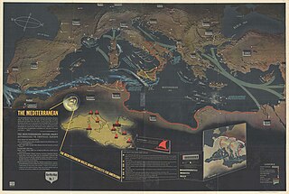
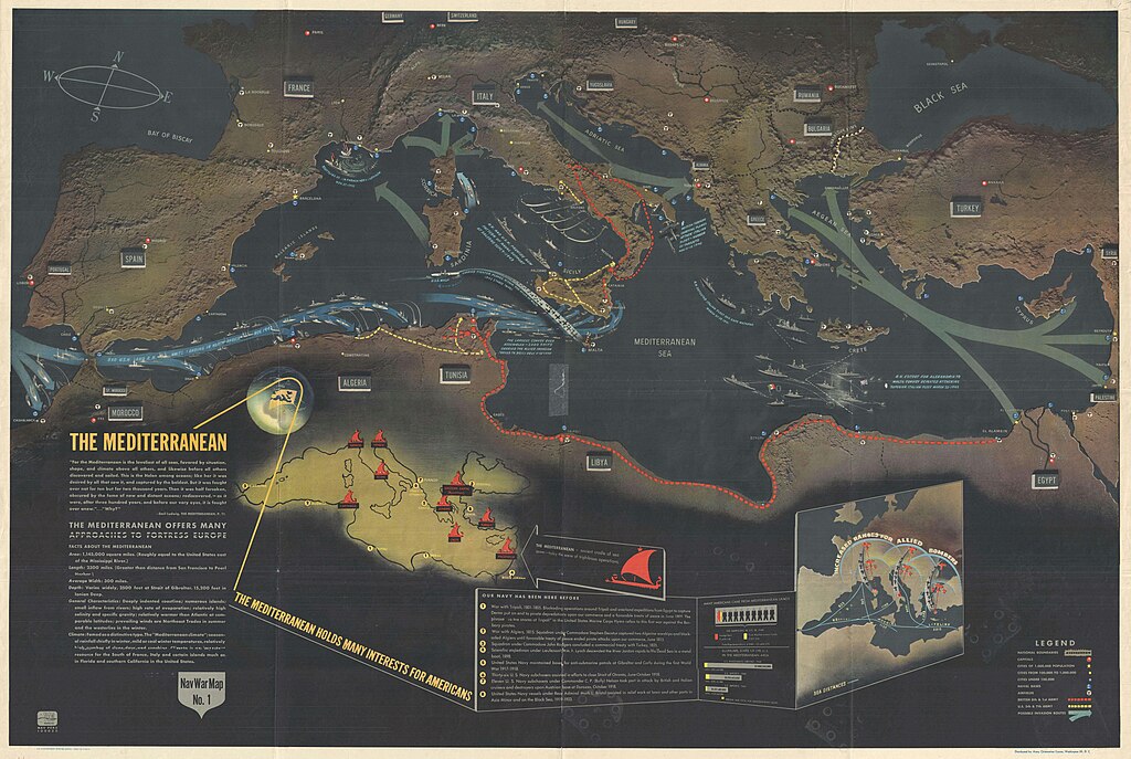
1944 Map - NavWarMap No. 1 - The Mediterranean.
Summary
edit
| Description |
English: 1944 Map - NavWarMap No. 1 - The Mediterranean. |
| Date | |
| Source | https://www.geographicus.com/P/AntiqueMap/navwarmap1-navy-1944 |
| Author | Bureau of Naval Personnel, |
Licensing
edit
This work is in the public domain in the United States because it is a work prepared by an officer or employee of the United States Government as part of that person’s official duties under the terms of Title 17, Chapter 1, Section 105 of the US Code.
Note: This only applies to original works of the Federal Government and not to the work of any individual U.S. state, territory, commonwealth, county, municipality, or any other subdivision. This template also does not apply to postage stamp designs published by the United States Postal Service since 1978. (See § 313.6(C)(1) of Compendium of U.S. Copyright Office Practices). It also does not apply to certain US coins; see The US Mint Terms of Use.
|
 | |
| This file has been identified as being free of known restrictions under copyright law, including all related and neighboring rights. | ||
File history
Click on a date/time to view the file as it appeared at that time.
| Date/Time | Thumbnail | Dimensions | User | Comment | |
|---|---|---|---|---|---|
| current | 20:41, 9 March 2020 | | 9,000 × 6,040 (9.73 MB) | Balkanique (talk | contribs) | Uploaded a work by Bureau of Naval Personnel, from https://www.geographicus.com/P/AntiqueMap/navwarmap1-navy-1944 with UploadWizard |
You cannot overwrite this file.
File usage on Commons
The following page uses this file:
- File:1944 Map - NavWarMap No. 1 - The Mediterranean.jpg (file redirect)