File:Naxal Left-wing violence or activity affected districts of India 2018.svg

Size of this PNG preview of this SVG file: 532 × 599 pixels. Other resolutions: 213 × 240 pixels | 426 × 480 pixels | 682 × 768 pixels | 909 × 1,024 pixels | 1,818 × 2,048 pixels | 1,649 × 1,858 pixels.
Original file (SVG file, nominally 1,649 × 1,858 pixels, file size: 772 KB)
Captions
Captions
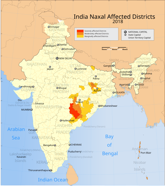
Map shows districts in India affected by Naxalites (Maoist far-left insurgents) as of 2018
Summary
edit
| Description |
English: Data source: https://satp.org/conflict-maps/india India Conflict Map April 2019 (2018 data) from the South Asian Terrorism Portal
This is a derivative work of File:India map Naxal Left-wing violence or activity affected districts 2013.SVG, available on wikimedia commons. The data and coloring has been updated in the above map to reflect 2018 information, as accessed in October 2021. Severely affected = 50+ casualties/year Moderately affected = 11-50 casualties/year Marginally affected = 1-10 casualties/year |
| Date | |
| Source | Own work |
| Author | Ganesha811 |
Licensing
edit
I, the copyright holder of this work, hereby publish it under the following license:
This file is licensed under the Creative Commons Attribution-Share Alike 4.0 International license.
- You are free:
- to share – to copy, distribute and transmit the work
- to remix – to adapt the work
- Under the following conditions:
- attribution – You must give appropriate credit, provide a link to the license, and indicate if changes were made. You may do so in any reasonable manner, but not in any way that suggests the licensor endorses you or your use.
- share alike – If you remix, transform, or build upon the material, you must distribute your contributions under the same or compatible license as the original.
File history
Click on a date/time to view the file as it appeared at that time.
| Date/Time | Thumbnail | Dimensions | User | Comment | |
|---|---|---|---|---|---|
| current | 01:14, 25 October 2021 | | 1,649 × 1,858 (772 KB) | Ganesha811 (talk | contribs) | Uploaded own work with UploadWizard |
You cannot overwrite this file.
File usage on Commons
There are no pages that use this file.
File usage on other wikis
The following other wikis use this file:
- Usage on ca.wikipedia.org
- Usage on en.wikipedia.org
- Usage on es.wikipedia.org
- Usage on fi.wikipedia.org
- Usage on fr.wikipedia.org
- Usage on hu.wikipedia.org
- Usage on pa.wikipedia.org
- Usage on pnb.wikipedia.org
- Usage on pt.wikipedia.org
- Usage on ru.wikipedia.org
- Usage on ur.wikipedia.org
- Usage on zh.wikipedia.org