File:Nebraska370.svg

Size of this PNG preview of this SVG file: 800 × 369 pixels. Other resolutions: 320 × 148 pixels | 640 × 295 pixels | 1,024 × 472 pixels | 1,280 × 590 pixels | 2,560 × 1,181 pixels.
Original file (SVG file, nominally 800 × 369 pixels, file size: 1.15 MB)
Captions
Captions
Add a one-line explanation of what this file represents
| Description |
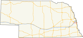
English: Map of Nebraska Highway 370. Created using Inkscape and Quantum GIS. |
| Date | |
| Source | Own work |
| Author | Fredddie |
| SVG development |
| I, the copyright holder of this work, release this work into the public domain. This applies worldwide. In some countries this may not be legally possible; if so: I grant anyone the right to use this work for any purpose, without any conditions, unless such conditions are required by law. |
File history
Click on a date/time to view the file as it appeared at that time.
| Date/Time | Thumbnail | Dimensions | User | Comment | |
|---|---|---|---|---|---|
| current | 16:13, 8 February 2012 | | 800 × 369 (1.15 MB) | Fredddie (talk | contribs) | Reverted to version as of 20:00, 15 December 2009 |
| 23:58, 20 December 2009 |  | 800 × 369 (1.15 MB) | Fredddie (talk | contribs) | add Iowa 370 | |
| 20:00, 15 December 2009 |  | 800 × 369 (1.15 MB) | Fredddie (talk | contribs) | {{Information |Description={{en|1=Map of Nebraska Highway 370. Created using Inkscape and Quantum GIS.}} |Source={{Own}} |Author=Fredddie |Date=2009-12-15 |Permission= |other_versions= }} {{pd-self}} [[Category:Road maps of Nebraska|370] |
You cannot overwrite this file.
File usage on Commons
The following page uses this file:
File usage on other wikis
The following other wikis use this file:
- Usage on www.wikidata.org