File:NeeltjeJans-natuur-OpenTopo.jpg
Size of this preview: 448 × 600 pixels. Other resolutions: 179 × 240 pixels | 358 × 480 pixels | 573 × 768 pixels | 765 × 1,024 pixels | 1,529 × 2,048 pixels | 2,632 × 3,524 pixels.
Original file (2,632 × 3,524 pixels, file size: 1.55 MB, MIME type: image/jpeg)
Captions
Captions
Add a one-line explanation of what this file represents
Summary edit
| Description |
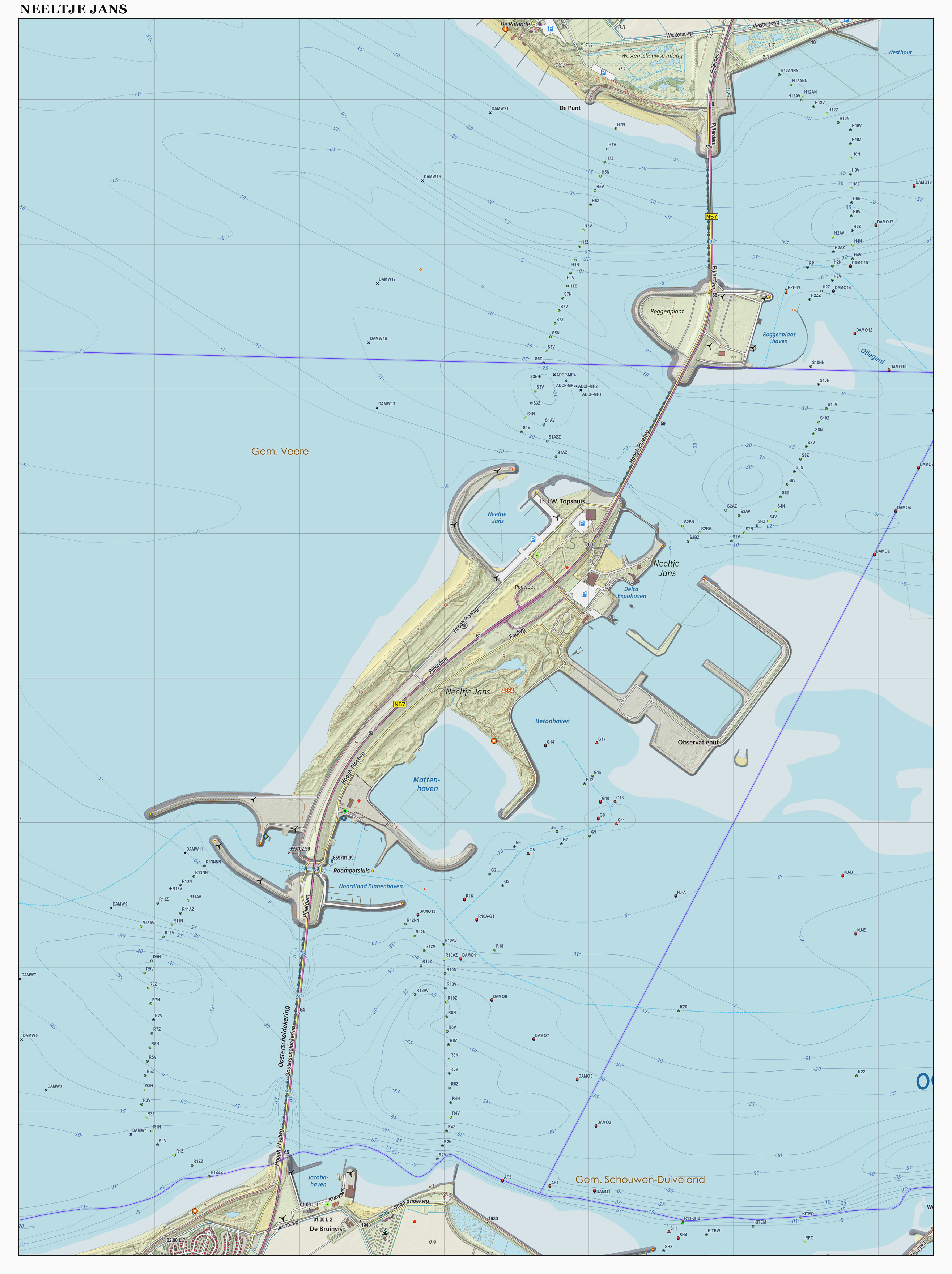
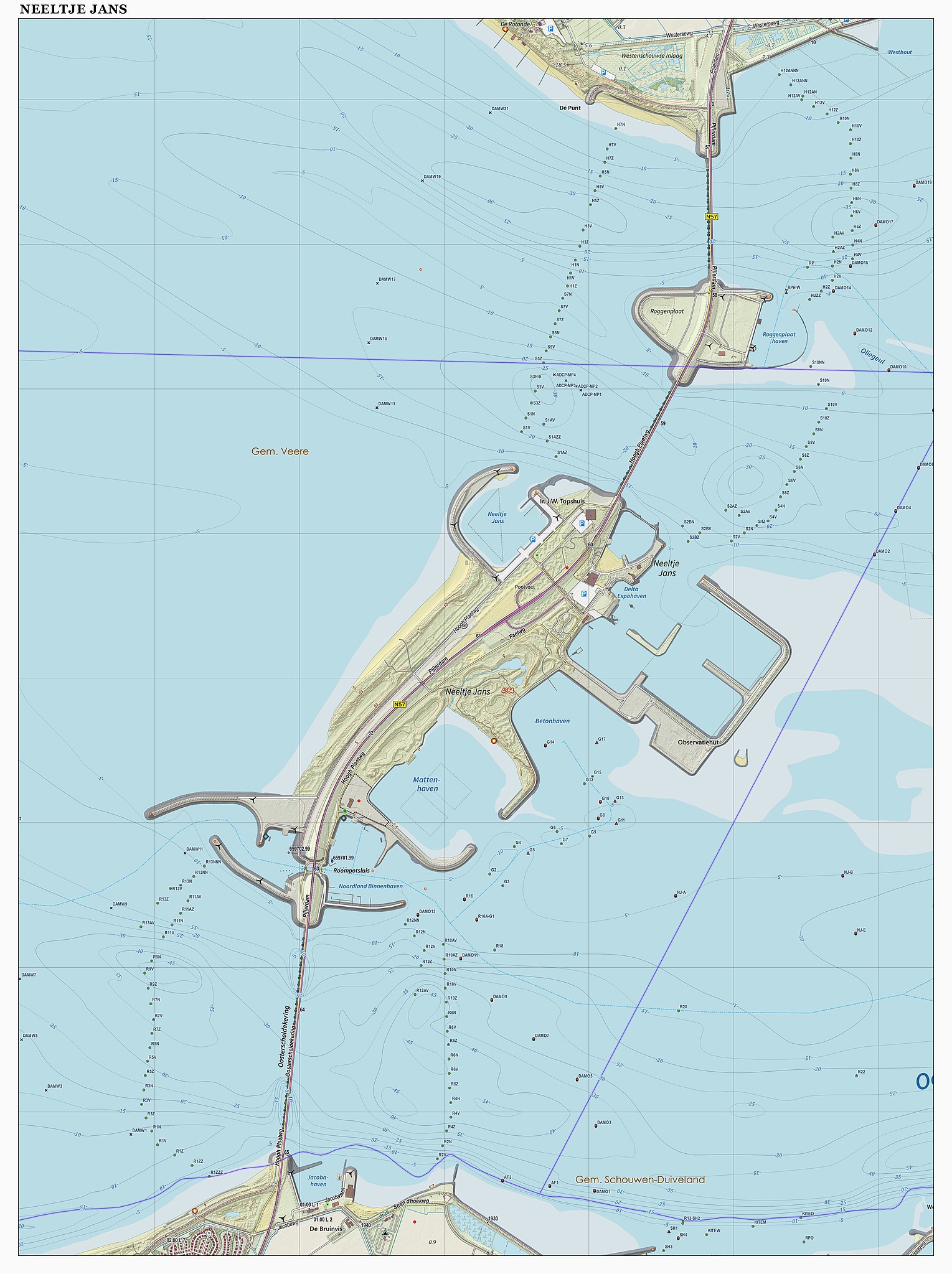
Nederlands: Topografische kaart van Neeltje Jans (natuurgebied). Resolutie: 400 pixels/km.
Samengesteld door Jan-Willem van Aalst op basis van de GML open geodata van de BRT/Top10NL (basisregistratie Topografie, Kadaster), vrijgegeven door Kadaster onder de Creative Commons BY licentie. Additionele gegevens uit BAG uit de Open Street Map en uit de Risicokaart. Zie ook de Legenda. |
| Date | |
| Source | Own work |
| Author | Janwillemvanaalst |
Licensing edit
I, the copyright holder of this work, hereby publish it under the following license:
This file is licensed under the Creative Commons Attribution-Share Alike 3.0 Unported license.
- You are free:
- to share – to copy, distribute and transmit the work
- to remix – to adapt the work
- Under the following conditions:
- attribution – You must give appropriate credit, provide a link to the license, and indicate if changes were made. You may do so in any reasonable manner, but not in any way that suggests the licensor endorses you or your use.
- share alike – If you remix, transform, or build upon the material, you must distribute your contributions under the same or compatible license as the original.
File history
Click on a date/time to view the file as it appeared at that time.
| Date/Time | Thumbnail | Dimensions | User | Comment | |
|---|---|---|---|---|---|
| current | 16:15, 31 December 2015 | | 2,632 × 3,524 (1.55 MB) | Janwillemvanaalst (talk | contribs) | Map layers update, Dec. 2015 |
| 13:13, 25 July 2015 |  | 2,634 × 3,526 (1.6 MB) | Janwillemvanaalst (talk | contribs) | Map layers update, June 2015 | |
| 10:44, 15 March 2015 |  | 2,632 × 3,524 (1.24 MB) | Janwillemvanaalst (talk | contribs) | Map layers update, March 2015 | |
| 18:28, 28 December 2014 |  | 2,149 × 2,901 (1.29 MB) | Janwillemvanaalst (talk | contribs) | Map layers update, Dec. 2014 | |
| 14:59, 15 October 2014 |  | 2,149 × 2,901 (1.92 MB) | Janwillemvanaalst (talk | contribs) | Map layers update, Sept. 2014 | |
| 15:29, 28 June 2014 |  | 2,149 × 2,901 (2.74 MB) | Janwillemvanaalst (talk | contribs) | Map layers update, June 2014 | |
| 17:53, 22 March 2014 |  | 2,149 × 2,901 (1.23 MB) | Janwillemvanaalst (talk | contribs) | User created page with UploadWizard |
You cannot overwrite this file.
File usage on Commons
The following page uses this file:
File usage on other wikis
The following other wikis use this file:
- Usage on arz.wikipedia.org
- Usage on ca.wikipedia.org
- Usage on ceb.wikipedia.org
- Usage on en.wikipedia.org
- Usage on es.wikipedia.org
- Usage on it.wikipedia.org
- Usage on nl.wikipedia.org
- Usage on pt.wikipedia.org
- Usage on www.wikidata.org
- Usage on zea.wikipedia.org