File:Ness railway viaduct, Inverness Harbour - geograph.org.uk - 960014.jpg
No higher resolution available.
Ness_railway_viaduct,_Inverness_Harbour_-_geograph.org.uk_-_960014.jpg (640 × 480 pixels, file size: 89 KB, MIME type: image/jpeg)
Captions
Captions
Add a one-line explanation of what this file represents
Summary
edit
| Description |
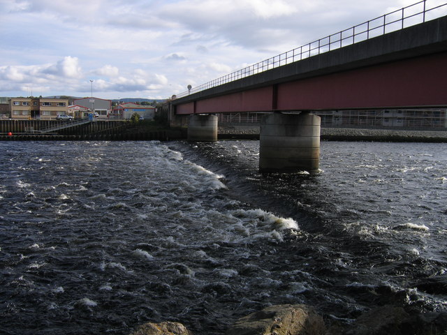
English: Ness railway viaduct, Inverness Harbour Taken from Anderson Street on the west side of the river, this is the new bridge provided in the early 1990s when the previous bridge collapsed in spectacular fashion, its piers having been undermined by scouring of the river bed during periods of flood. A number of trains were stranded on the suddenly isolated Far North and Kyle of Lochalsh lines. Note the line of turbulence close to the bridge as the incoming tide meets the outflow from Loch Ness coming down the river. |
| Date | |
| Source | From geograph.org.uk |
| Author | A-M-Jervis |
| Attribution (required by the license) | A-M-Jervis / Ness railway viaduct, Inverness Harbour / |
| Camera location | | View this and other nearby images on: OpenStreetMap |
|---|
_heading:135.00&language=en)
| Object location | | View this and other nearby images on: OpenStreetMap |
|---|
_heading:135.00&language=en)
Licensing
edit

|
This image was taken from the Geograph project collection. See this photograph's page on the Geograph website for the photographer's contact details. The copyright on this image is owned by A-M-Jervis and is licensed for reuse under the Creative Commons Attribution-ShareAlike 2.0 license.
|
This file is licensed under the Creative Commons Attribution-Share Alike 2.0 Generic license.
Attribution: A-M-Jervis
- You are free:
- to share – to copy, distribute and transmit the work
- to remix – to adapt the work
- Under the following conditions:
- attribution – You must give appropriate credit, provide a link to the license, and indicate if changes were made. You may do so in any reasonable manner, but not in any way that suggests the licensor endorses you or your use.
- share alike – If you remix, transform, or build upon the material, you must distribute your contributions under the same or compatible license as the original.
File history
Click on a date/time to view the file as it appeared at that time.
| Date/Time | Thumbnail | Dimensions | User | Comment | |
|---|---|---|---|---|---|
| current | 17:25, 22 February 2011 | | 640 × 480 (89 KB) | GeographBot (talk | contribs) | == {{int:filedesc}} == {{Information |description={{en|1=Ness railway viaduct, Inverness Harbour Taken from Anderson Street on the west side of the river, this is the new bridge provided in the early 1990s when the previous bridge collapsed in spectacular |
You cannot overwrite this file.
File usage on Commons
There are no pages that use this file.