File:Netherlands, Leidschendam-Voorburg, Starrevaart (3).JPG
Original file (3,531 × 2,560 pixels, file size: 1.08 MB, MIME type: image/jpeg)
Captions
Captions
Summary
edit.JPG&action=edit§ion=1)
| Description |
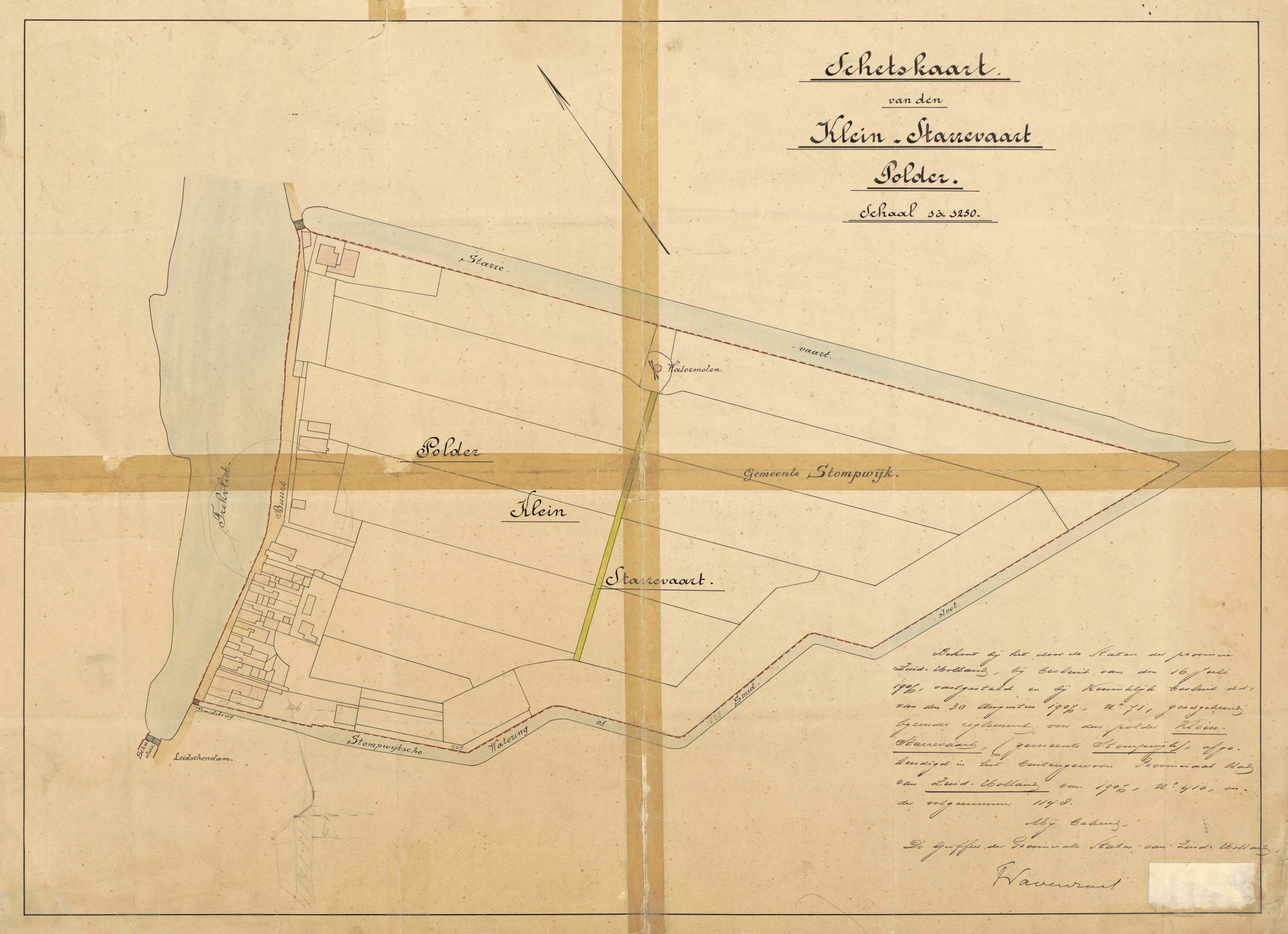
Nederlands: Polderreglementskaart uit 1907 van de polder Klein Starrevaart te Leidschendam (gemeenten Leidschendam-Voorburg, indertijd gelegen in de gemeente Stompwijk, Provincie Zuid-Holland). Het bijschrift op de kaart luidt: "Schetskaart van den Klein-Starrevaart Polder. Schaal 1 à 1250. Behoort bij het door de Staten der Provincie Zuid-Holland, bij besluit van den 16 Juli 1907, vastgesteld en bij Koninklijk besluit dd. van den 30 Augustus 1907, N° 71, goedgekeurd bijzonder reglement voor den Polder Klein Starrevaart, (gemeente Stompwijk), afgekondigd in het buitengewoon Provinciaal blad van Zuid-Holland van 1907, N° 410, onder volgnummer 1148. Mij bekend, De griffier der Provinciale staten van Zuid-Holland, (handtekening)."
English: Map of 1907 of the polder Klein Starrevaart in Leidschendam (municipality of Leidschendam-Voorburg, Prov. of South Holland, Netherlands). In 1907 the polder was part of the municipality of Stompwijk. The map belongs to a set of official rules, drafted for the water management of the polder. |
| Date | |
| Source | National Archives of the Netherlands . [Nationaal Archief, Den Haag, ZHPB2 Provinciaal Bestuur Zuid-Holland: Polderreglementskaarten,1857-1974, nummer toegang 4.ZHPB2, inventarisnummer 442] Zie ook: http://www.gahetna.nl/collectie/afbeeldingen/kaartencollectie/zoeken/weergave/detail/start/1/tstart/0/q/zoekterm/starrevaart |
| Author | Unknown author |
| Permission (Reusing this file) |
The archive listing, in which this file is incorporated, states that there are no copyright limitations attached to this file. See: http://www.gahetna.nl/collectie/archief/pdf/NL-HaNA_4.ZHPB2.ead.pdf [De archiefInventaris van de Polderreglementskaarten, behorende tot het archief van het Provinciaal Bestuur van Zuid-Holland, 1857-1974, nummer 4.ZHPB2, stelt letterlijk: "Er zijn geen beperkingen krachtens het auteursrecht". Zie de pdf-link.] |
The center of the polder is located at:
| Camera location | | View this and other nearby images on: OpenStreetMap |
|---|
.JPG¶ms=052.080019_N_0004.402686_E_globe:Earth_type:camera_region:NL_&language=en)
Licensing
edit.JPG&action=edit§ion=2)
|
This work is in the public domain in its country of origin and other countries and areas where the copyright term is the author's life plus 70 years or fewer.
| |
| This file has been identified as being free of known restrictions under copyright law, including all related and neighboring rights. | |
File history
Click on a date/time to view the file as it appeared at that time.
| Date/Time | Thumbnail | Dimensions | User | Comment | |
|---|---|---|---|---|---|
| current | 13:52, 28 November 2011 | | 3,531 × 2,560 (1.08 MB) | Loranchet (talk | contribs) | {{Information |Description ={{nl|1=Polderreglementskaart uit 1907 van de polder Klein Starrevaart te Leidschendam (gemeenten Leidschendam-Voorburg, indertijd gelegen in de gemeente Stompwijk, Provincie Zuid-Holland). Het bijschrift op de kaart luidt: " |
You cannot overwrite this file.
File usage on Commons
There are no pages that use this file.
File usage on other wikis
The following other wikis use this file:
- Usage on nl.wikipedia.org
.JPG&oldid=765983223)