File:Netherlands, Zuidland, map of 1866.jpg
Size of this preview: 737 × 600 pixels. Other resolutions: 295 × 240 pixels | 590 × 480 pixels | 944 × 768 pixels | 1,259 × 1,024 pixels | 2,549 × 2,074 pixels.
Original file (2,549 × 2,074 pixels, file size: 1.74 MB, MIME type: image/jpeg)
Captions
Captions
Add a one-line explanation of what this file represents
Summary edit
| Description |
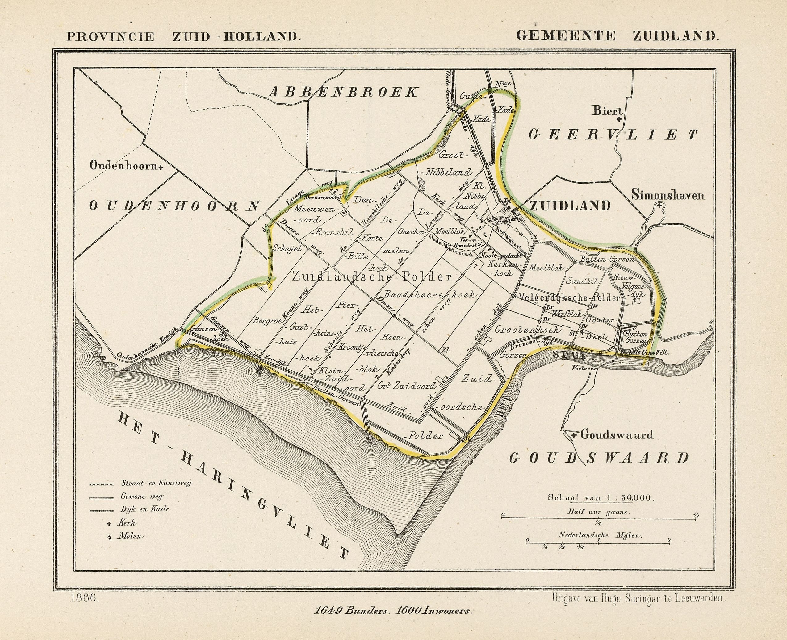
Nederlands: Kaart uit 1866 van de voormalige gemeente Zuidland (prov. Zuid-Holland). Deze gemeente bestond ca. 168 jaar, vanaf het moment dat de gemeente als bestuursvorm werd ingevoerd tot 1 jan. 1980. Op die datum fuseerden de gemeenten Zuidland, Abbenbroek, Geervliet, Oudenhoorn en een deel van Heenvliet tot de nieuwe gemeente Bernisse. Zuidland ligt ca. 18,4 km ten zuidwesten van Rotterdam.
English: Map from 1866 of the former municipality of Zuidland (province South Holland, Netherlands). On January 1st, 1980 the municipalities of Zuidland, Abbenbroek, Geervliet, Oudenhoorn and a part of Heenvliet melted together to form the new municipality Bernisse. Zuidland lies about 18.4 km southwest of Rotterdam. |
| Date | 1866. Published around 1870 as part of a series of provincial atlases of the Netherlands. |
| Source | Gemeente-atlas van Nederland naar officieele bronnen bewerkt. [EN: "Atlas of Netherlands' municipalities, edited after official sources"] |
| Author | J. Kuyper |
| Permission (Reusing this file) |
EN: This image is in the public domain. The author J. Kuyper died in 1908. In the Netherlands copyright expires 70 years after the death of the author or 70 years after first publication in the case of anonymous or pseudonymous works or works published by a legal entity. NL: Dit werk is in het publieke domein. De auteur J. Kuyper overleed in 1908. Het auteursrecht in Nederland vervalt 70 jaar na de dood van de auteur of 70 jaar na de eerste openbaarmaking van het werk, indien het gaat om een anoniem of om een onder pseudoniem verschenen werk of werk van een rechtspersoon. |
The church in Zuidland (as indicated with a + on the map) is located at:
| Camera location | | View this and other nearby images on: OpenStreetMap |
|---|
Licensing edit
|
This work is in the public domain in its country of origin and other countries and areas where the copyright term is the author's life plus 70 years or fewer. This work is in the public domain in the United States because it was published (or registered with the U.S. Copyright Office) before January 1, 1929. | |
| This file has been identified as being free of known restrictions under copyright law, including all related and neighboring rights. | |
File history
Click on a date/time to view the file as it appeared at that time.
| Date/Time | Thumbnail | Dimensions | User | Comment | |
|---|---|---|---|---|---|
| current | 20:49, 21 December 2012 | | 2,549 × 2,074 (1.74 MB) | Loranchet (talk | contribs) | {{Information |Description ={{nl|1=Kaart uit 1866 van de voormalige gemeente Zuidland (prov. Zuid-Holland). Deze gemeente bestond ca. 168 jaar, vanaf het moment dat de gemeente als bestuursvorm werd ingevoerd tot 1 jan. 1980. Op die datum fuseerden ... |
You cannot overwrite this file.
File usage on Commons
There are no pages that use this file.