File:Nevada Wildfire (MODIS 2020-07-09).jpg

Original file (1,689 × 1,344 pixels, file size: 267 KB, MIME type: image/jpeg)
Captions
Captions
Summary
edit.jpg&action=edit§ion=1)
| Description |
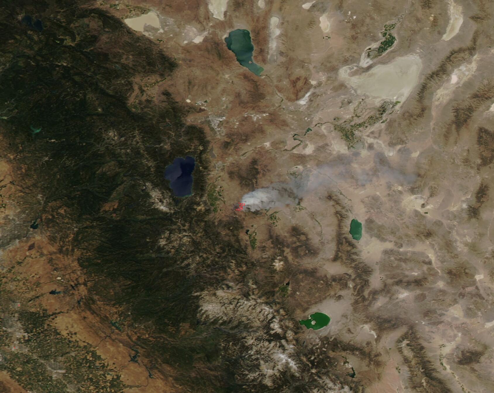
English: On July 6, 2020, residents living east of Gardnerville, Nevada, noticed a robust emergency response to a small fire that had sparked in grass, brush, and pinyon juniper. Within 24 hours the explosive fire had scorched 17,296 acres and consumed one structure and 10 outbuildings. The Moderate Resolution Imaging Spectroradiometer (MODIS) on board NASA’s Terra satellite acquired a true-color image of the Numbers Fire on July 7. Lake Tahoe sits to the northwest of the Numbers Fire.
On July 6, a private citizen posted on a Nevada wildfire Facebook page “This hot spot just erupted about 8:30 p.m. tonight…it was a small puff then grew SO fast.” Evacuations were quickly ordered for residents of Pine View Estates, Bodie Flats, Our Our Way Area, Blue Bird, and Lena Way. Route 395 was closed at Riverview and SR 208 and Pinenut was closed Arroyo that same evening. The Douglas County Department of Emergency Management notified residents that shelters were located at specific local hotels and that livestock and domestic pets would be sheltered at the Douglas County Fairgrounds. Firefighting efforts initially centered on public safety and protection of structures and these efforts have been supported by multiple local, state, and federal fire agencies. On July 7, the Numbers fire had reached and burned into the 2,323-acre Monarch Fire that started on June 26. No additional structures were damaged on that day. As of the morning of July 8, the Numbers Fire has consumed approximately 18,000 acres, according to InciWeb Incident Information System. It is 5 percent contained, with no injuries or additional structural damage. All evacuations are lifted with the exception of Pinenut 2 Road East of Out Our Way. Dry, breezy weather is predicted, which may aid in fire spread. The cause of the fire is under investigation. The following request for information has been made: “Fire officials on the Numbers Fire, 10 miles southeast of Gardnerville Nevada, seek public assistance with a multi-agency investigation. Anyone traveling Hwy 395 between Ridge View and Holbrook Junction on July 6, 2020, around 6:30-7:30 p.m. Anyone with information is asked to email 2020firetips@gmail.com. All information will be kept confidential.” |
||
| Date | Taken on 7 July 2020 | ||
| Source |
|
||
| Author | MODIS Land Rapid Response Team, NASA GSFC |
| This media is a product of the Terra mission Credit and attribution belongs to the mission team, if not already specified in the "author" row |
Licensing
edit.jpg&action=edit§ion=2)
| This file is in the public domain in the United States because it was solely created by NASA. NASA copyright policy states that "NASA material is not protected by copyright unless noted". (See Template:PD-USGov, NASA copyright policy page or JPL Image Use Policy.) | ||
 |
Warnings:
|
File history
Click on a date/time to view the file as it appeared at that time.
| Date/Time | Thumbnail | Dimensions | User | Comment | |
|---|---|---|---|---|---|
| current | 02:59, 17 February 2024 | | 1,689 × 1,344 (267 KB) | OptimusPrimeBot (talk | contribs) | #Spacemedia - Upload of http://modis.gsfc.nasa.gov/gallery/images/image07092020_250m.jpg via Commons:Spacemedia |
You cannot overwrite this file.
File usage on Commons
There are no pages that use this file.
.jpg&oldid=852770541)