File:Nevada Wildlife Management Units.svg

Size of this PNG preview of this SVG file: 405 × 599 pixels. Other resolutions: 162 × 240 pixels | 325 × 480 pixels | 519 × 768 pixels | 693 × 1,024 pixels | 1,385 × 2,048 pixels | 5,265 × 7,783 pixels.
Original file (SVG file, nominally 5,265 × 7,783 pixels, file size: 419 KB)
Captions
Captions
Add a one-line explanation of what this file represents
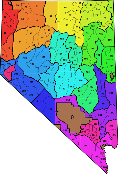
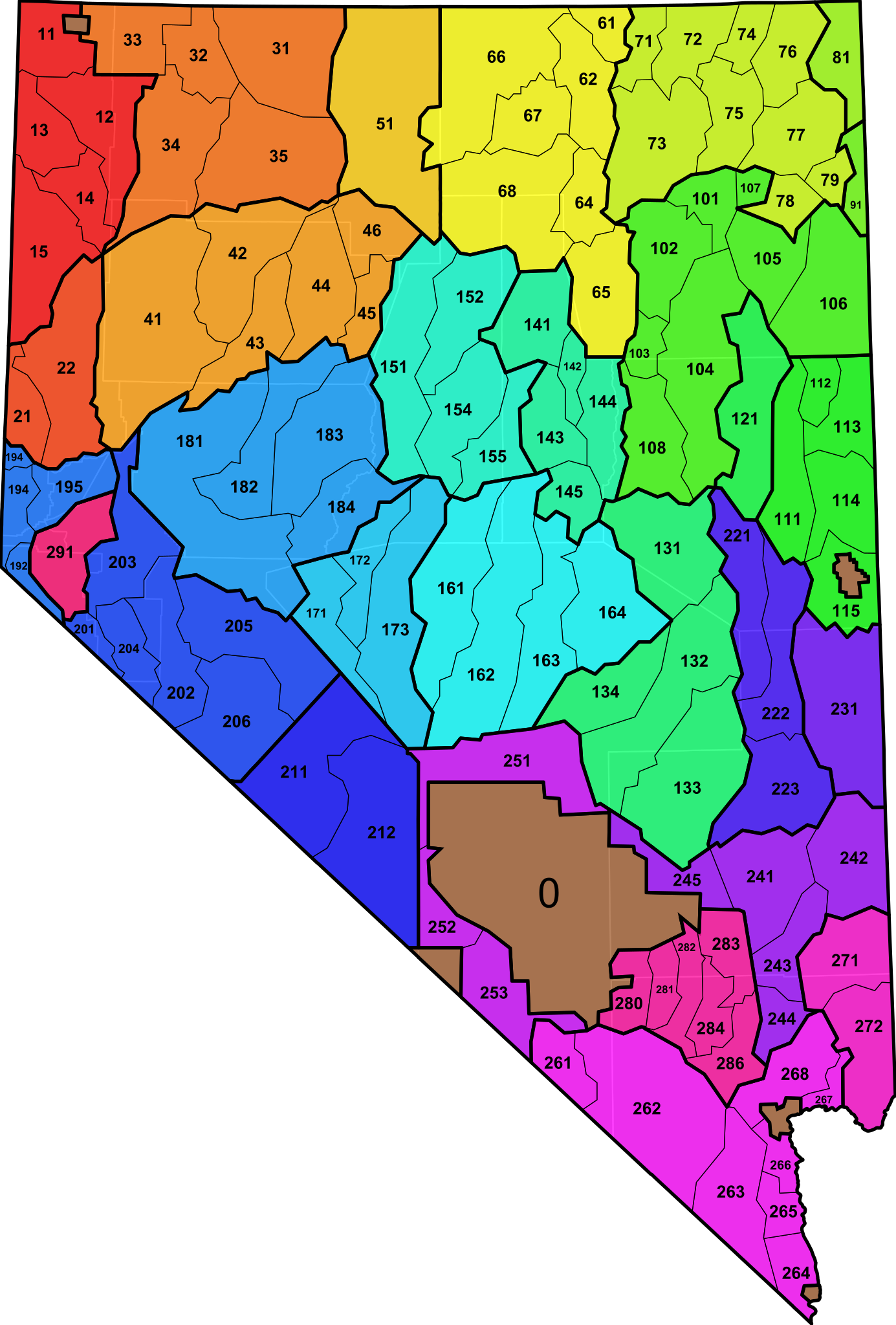
| Description | An SVG map of Utah showing the 115 wildlife management units. The units are semi-transparent so that county boundaries can be visualized. Data from here. See also here. |
| Date | (UTC) |
| Source | |
| Author |
|
I, the copyright holder of this work, hereby publish it under the following license:
| I, the copyright holder of this work, release this work into the public domain. This applies worldwide. In some countries this may not be legally possible; if so: I grant anyone the right to use this work for any purpose, without any conditions, unless such conditions are required by law. |
Original upload log
edit
This image is a derivative work of the following images:
- File:Blank_Map_of_Nevada.svg licensed with PD-self
- 2011-03-30T00:45:30Z Ninjatacoshell 5265x7783 (38715 Bytes) {{Information |Description=A blank SVG map of Nevada showing the 17 counties. |Source=*[[:File:Map_of_Nevada_highlighting_Washoe_County.svg|]] |Date=2011-03-30 00:41 (UTC) |Author=*[[:File:Map_of_Nevada_highlighting_Washoe_Co
Uploaded with derivativeFX
File history
Click on a date/time to view the file as it appeared at that time.
| Date/Time | Thumbnail | Dimensions | User | Comment | |
|---|---|---|---|---|---|
| current | 02:30, 30 March 2011 | | 5,265 × 7,783 (419 KB) | Ninjatacoshell (talk | contribs) | Put in missing unit 91 and changed colors and line widths to better delineate units and subunits. |
| 01:26, 30 March 2011 |  | 5,265 × 7,783 (388 KB) | Ninjatacoshell (talk | contribs) | {{Information |Description=An SVG map of Utah showing the 115 wildlife management units. The units are semi-transparent so that county boundaries can be visualized. Data from [http://plicmapcenter.org/view.php?st=NV&ag=BLM&typ=Hunting here]. See also [htt |
You cannot overwrite this file.
File usage on Commons
The following page uses this file: