File:New Caledonia - Envisat.jpg

Size of this preview: 800 × 506 pixels. Other resolutions: 320 × 202 pixels | 640 × 404 pixels | 1,024 × 647 pixels | 1,280 × 809 pixels | 2,318 × 1,465 pixels.
Original file (2,318 × 1,465 pixels, file size: 1.41 MB, MIME type: image/jpeg)
Captions
Captions
Add a one-line explanation of what this file represents
Summary edit
| Description |
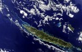
English: The New Caledonia archipelago, 1210 km east of Australia, is captured in this Envisat image, acquired on 5 July 2011. The main island, Grande Terre, dominates the image, stretching 350 km long from northwest to southeast. A mountain range runs the length of the island – its highest point reaching over 1620 m – and divides the land’s lush east from the savannahs in the west. A coral reef surrounds the main island and stretches into the Coral Sea to the northwest. The reef provides an important nesting site for green sea turtles and is home to endangered dugongs.
This image is featured on theEarth from Space video programme. |
| Date | |
| Source | http://www.esa.int/spaceinimages/Images/2013/02/New_Caledonia |
| Author | European Space Agency |
| Permission (Reusing this file) |
ESA,CC BY-SA 3.0 IGO |
| Other versions |
|
| Title | New Caledonia |
| System | Envisat Satellite |
| Keywords | Coral; Islands |
| Set | Earth observation image of the week |
| Mission | Envisat |
| Activity | Observing the Earth |
Licensing edit
This file is licensed under the Creative Commons Attribution-ShareAlike 3.0 IGO license.
Attribution: ESA
- You are free:
- to share – to copy, distribute and transmit the work
- to remix – to adapt the work
- Under the following conditions:
- attribution – You must give appropriate credit, provide a link to the license, and indicate if changes were made. You may do so in any reasonable manner, but not in any way that suggests the licensor endorses you or your use.
- share alike – If you remix, transform, or build upon the material, you must distribute your contributions under the same or compatible license as the original.
File history
Click on a date/time to view the file as it appeared at that time.
| Date/Time | Thumbnail | Dimensions | User | Comment | |
|---|---|---|---|---|---|
| current | 01:51, 22 February 2017 | | 2,318 × 1,465 (1.41 MB) | Revent (talk | contribs) | =={{int:filedesc}}== {{Photograph |photographer = Envisat satellite |title = New Caledonia |description = {{en|The New Caledonia archipelago, 1210 km east of Australia, is captured in this Envisat image, acquired on 5 July... |
You cannot overwrite this file.
File usage on Commons
The following 3 pages use this file:
File usage on other wikis
The following other wikis use this file:
- Usage on en.wikipedia.org
- Usage on es.wikipedia.org