File:Newport news norfolk portsmouth.jpg

Size of this preview: 608 × 600 pixels. Other resolutions: 243 × 240 pixels | 487 × 480 pixels | 779 × 768 pixels | 1,038 × 1,024 pixels | 2,077 × 2,048 pixels | 3,904 × 3,850 pixels.
Original file (3,904 × 3,850 pixels, file size: 11.39 MB, MIME type: image/jpeg)
Captions
Captions
Add a one-line explanation of what this file represents
Summary
edit
| Description |
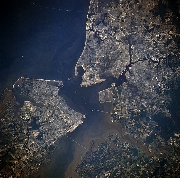
English: (From left uppermost, going clockwise:) Hampton, Norfolk, Portsmouth, Suffolk, and Newport News, Virginia, USA. - July 1996
One can see the major roadways throughout Hampton Roads, starting from the top with the Chesapeake-Bay Bridge-Tunnel (it has three bridge spans and two tunnel spans, seen with the gaps). The next down is the Hampton-Roads Bridge-Tunnel, connecting Hampton and Norfolk. Going further down, one sees the Monitor-Merrimack Memorial Bridge-Tunnel, connecting the tip of Newport News (near Northrop Grumman - Newport News shipyard) to Suffolk. Continuing down the major river (the James River, to be exact), one sees the James River Bridge, a draw-bridge, also connecting Newport News with Suffolk. Another visible landmark is the Fort Monroe Military Installation, located directly next to the Hampton Roads Bridge-Tunnel. This is one of the oldest fortifications in the United States, and has been occupied at various times through its history by Gen. Robert E. Lee and famous author Edgar Allan Poe. During the Civil War, Fort Monroe remained unbeseiged by the Confederacy, because, according to rumor, Gen. Lee knew that the fort would not fall. It retains the old fortification design inherited from Great Britain and Europe, characterised by a central island surrounded by a moat. This photograph is rotated approximately 120 degrees clockwise from true north. Norfolk, Portsmouth, and Suffolk are all part of the "Southside". |
| Date | |
| Source | https://eol.jsc.nasa.gov/SearchPhotos/photo.pl?mission=NM21&roll=774&frame=49 |
| Author | NASA |
This image or video was catalogued by one of the centers of the United States National Aeronautics and Space Administration (NASA) under Photo ID: NM21-774-49. This tag does not indicate the copyright status of the attached work. A normal copyright tag is still required. See Commons:Licensing. Other languages:
|
Licensing
edit
| This file is in the public domain in the United States because it was solely created by NASA. NASA copyright policy states that "NASA material is not protected by copyright unless noted". (See Template:PD-USGov, NASA copyright policy page or JPL Image Use Policy.) | ||
 |
Warnings:
|
Original upload log
edit
The original description page was here. All following user names refer to en.wikipedia.
- 2005-04-03 22:23 Darwinek 639×631×8 (136057 bytes)
File history
Click on a date/time to view the file as it appeared at that time.
| Date/Time | Thumbnail | Dimensions | User | Comment | |
|---|---|---|---|---|---|
| current | 21:32, 24 July 2023 | | 3,904 × 3,850 (11.39 MB) | Don-vip (talk | contribs) | |
| 12:47, 26 June 2008 |  | 639 × 631 (133 KB) | File Upload Bot (Magnus Manske) (talk | contribs) | {{BotMoveToCommons|en.wikipedia}} {{Information |Description={{en|(From left uppermost, going clockwise:) Hampton, Norfolk, Portsmouth, Suffolk, and Newport News, Virginia, USA. - July 1996 One can see the major roadways throughout Hampton Roads, startin |
You cannot overwrite this file.
File usage on Commons
There are no pages that use this file.
File usage on other wikis
The following other wikis use this file:
- Usage on en.wikipedia.org
- Usage on www.wikidata.org