File:Ni-map.png
No higher resolution available.
Ni-map.png (328 × 349 pixels, file size: 14 KB, MIME type: image/png)
Captions
Captions
Add a one-line explanation of what this file represents
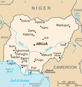
CIA map of Nigeria
This image is in the public domain because it contains materials that originally came from the United States Central Intelligence Agency's World Factbook.
|
 |
derivative works edit
Derivative works of this file: Ni-map-sv.png
File history
Click on a date/time to view the file as it appeared at that time.
| Date/Time | Thumbnail | Dimensions | User | Comment | |
|---|---|---|---|---|---|
| current | 04:52, 12 February 2022 | | 328 × 349 (14 KB) | Lojwe (talk | contribs) | Cropped 1 % horizontally, 1 % vertically using CropTool with precise mode. |
| 20:54, 4 March 2005 |  | 331 × 352 (15 KB) | Alfio (talk | contribs) | CIA map of Nigeria |
You cannot overwrite this file.
File usage on Commons
The following 4 pages use this file:
File usage on other wikis
The following other wikis use this file:
- Usage on cv.wikipedia.org
- Usage on de.wikinews.org
- Usage on en.wikipedia.org
- Usage on eo.wikipedia.org
- Usage on es.wikipedia.org
- Usage on et.wikipedia.org
- Usage on fi.wikivoyage.org
- Usage on gl.wikipedia.org
- Usage on ht.wikipedia.org
- Usage on hu.wikipedia.org
- Usage on hu.wiktionary.org
- Usage on it.wikipedia.org
- Usage on it.wikinews.org
- Usage on ja.wikipedia.org
- Usage on ja.wikinews.org
- Usage on la.wikipedia.org
- Usage on lfn.wikipedia.org
- Usage on mrj.wikipedia.org
- Usage on nn.wikipedia.org
- Usage on no.wikipedia.org
- Usage on pl.wikinews.org
- Usage on roa-tara.wikipedia.org
- Usage on ru.wikipedia.org
- Usage on scn.wikipedia.org
- Usage on sg.wikipedia.org
- Usage on sg.wiktionary.org
- Usage on sh.wikipedia.org
- Usage on sq.wikipedia.org
- Usage on sr.wikipedia.org
View more global usage of this file.